CHAPTER NO.3 AGENTS OF CHANGE:DENUDATION AND TRANSPORTATION
CHAPTER NO.3 AGENTS OF
CHANGE:DENUDATION AND TRANSPORTATION
The structure of Earth continuously changes by both,
internal forces
(volcanoes, earth quakes etc.) and external forces
(weathering, erosion, levelling of Earth’ s surface etc.)
Denudation : External forces work continuously on
levelling of outer surface of Earth and this activity is known as denudation.
Eroded materials settle down in lower areas,leading to levelling up of earth’s
surface which is techmcally known as aggredation.
When external forces erode the level of outer
surface of Earth the process, is
known as degradation. When these two activities of
erosion and deposition occur simultaneously, itis known as Gradation.

Denudation takes place because of heat of sun and
gravitationak pull. Weather
changes because of Sun’s heat which results in the
break down of rocks. Rivers flow from higher level to lower level because of
gravitation. This is known as Mass Wasting.Both weathering and erosion are the
tools of denudation.
Let us discuss in detail :
Weathering : Weather plays an important roles in
changing the structure of Earth. It works deep beneath the Earth’s surface and
also occurs over the crust of Earth and all surfaces in different forms.
Actually, the breakage of rocks because of weather on the surface of Earth is
known as weathering.
In other words, weathering is the breaking of rocks
by static agents of weather which include rain, frost, temperature changes etc.
According to B. Sparks,“Weathering is the mechanical fracturing and chemical
decomposition of rocks by the natuaral agents at the surface of Earth”.
Climate of a place, composition of Rocks, Flora etc.
have huge effect on the process of weathering. Humidity, rains, frost are the
important elements of weather,beceause of these the breaking, fracturing,
expansion and contaction (shrinking) of rocks takes place. Process of
weathering may be divided into three parts :—
1. Physical Weathering/Mechanical
Weathering :In this type of weathering rocks are
divided/disintegrated into different parts without any chemical change that is
why it is known as mechanical weathering. Three agents work on this type of
activity :—

(a) Insolation :
This process takes place mostly in deserts as during day
time rocks expand due to high temperature and
contract during night
with fall in temperature. Repetition of this activity results in disintegration of
rocks. Sometimes rocks disintegrate into small pieces, whichis known as
Granular disintegration. Although main reason for
physical weathering is
heat of sun yet winds and air pressures can also
cause such process.
(b) Frost-heaving :
Due to heat when cracks appear on rocks, rain water is filled in those cracks.
At night, water freezes because of low temperature and expands due to which
breakdown of rocks starts and they disintegrate into smaller parts. Mostly this
process takes place in mountainous regions. Sometime small stones comes out
from soil because of frost heaving and these stones make ring like structure.

(c) Exfoliation :
This activity takes place in desert areas. Rise and fall in temperature on
daily basis leads to disintegration of layers of rocks and due to high speed
winds these fine eroded layers get transported to far-flunged areas. This
process is known
as exfoliation.
2. Chemical Weathering :
In this weathering chemical structure of rock changes.Gases in Atmosphere and
rain lead to disintegration of rocks which brings physical as well as chemical
changes. This process is known as chemical weathering. Chemical weathering also
has various types :

(a) Oxidation :
In this process oxygen reacts with the iron particles present in rocks because
of which ferrous (rust) is formed. Due to oxidation, rocks attain red or yellow
colour. Rust leads to the disintegration of rocks in small particals.
(b) Carbonation :
When regions with high lime content receive rainfall, the
carbondioxide present in water reacts with lime and
carbonic acid is formed. Because of carbonic acid cracks turn into enlarged
deeps on rocks and continuity of this process disintegration of rocks takes
place.
(c) Hydration :
In this process in which rocks having metallic content absorb water which makes
structural change in type of rocks. Some rocks expand due to water absorption
like Feldspar changes into Kaolin. Vindheya Mountains situated near Jabalpur
are formed by this process.
(d) Solution : Some minerals
are easily dissolvable in water and rock salt, silica and gypsum like soft
rocks does not lose vanish by dissolving in water. Rock salt which is mostly
found in desert areas, carries on its identity because of less or negligible
rainfall in desert regions. Gypsum, which is not as
dissolvable as salt continues with its identity in humid regions where rock
salt dissolves.
3. Biological Weathering :
If activities of plants, animals and human beings result in to disintegration
of rocks, weathering caused is known as biological
weathering.

(a) Plants : Plants
contribute important type in physical and
chemical weathering. Expansion of roots with growth of plants, leads to
cracking of rocks. Further expansion results in disintegration of rocks.
(b) Bacterial Action :
Decomposition of leaves and roots form organic and nitric acids which on
reaction cause chemical weathering. “‘Humus’ is also formed in such process
only.
(c) Weathering by Animals :
Cracks appear on rocks because of ‘burrows’ of
animals. Many animals make their Funnels’ by
breaking rocks. All this results in the disintegration of rocks. Common animals
and insects performing such acts are; Foxes,Rats, Rabbits, Earthworms, Mites,
Ants etc.
(d) Human Actions :
Activities like search for minerals, construction of buildings,leveling of land
for agriculture, construction of roads
results in disintegration of rocks.
Deep quarrying for fulfilling need of stones is also
one of the agents that causes weathering results.
Weathering effect is not same or similar for all
types of rocks. Various factors
like weather, atmosphere, structure etc. affect their process.

Mass wasting is also known as slope movement or mass movement, is
a process by which soil, sand and rocks move downslope. This brings change in
the structure of
rocks. The structure itself indicates the change
which weathering brings in parent rock.Weathering process may be quite fast on
some rocks while slow on others.
Sometimes due to gravitational pull, the debris
stops at higher spot on a slope.
‘Creep’ is the type when debris is creeping
downslope while fall at high speed is known as ‘Fall’. Falling big parts of
broken rocks are known as “Talus’ and smaller ones as *Scree’.

When these broken rocks fall at high speed, huge
loss of life and property
occurs. During rainfall these activities are very
commonin hilly regions. Mud flows downslopes at the speed of 80 km/hr/50 mph.
This process is known as mud flow.In other words, movement of soil and regolith
that more resembles fluid behaviour is called a ‘flow’.

Erosion :
Word ‘erosion’ has been derived from the word ‘erodese’ of Latin
Language, which means ‘to gnaw’. In simple words, it
is a process in which rivers,glaciers, winds, undergroud water removes soil and
rocks from one place and transport them to another place, where they are
deposited. Weathering, Erosion and Denudation are deeply related to each other
and depend on each other for their accomplishment. Means of erosion perform
three task i.e. Removal, Transportation and Deposition.
(i) Denudation Works of River Structure of Earth
changes continously due to erosion. Water which is near omni present, plays
most important role in the process of erosion, even more than air. That is why
itis soimportant that at first step we should known about works of rivers.When
it rains or when ice melts on mountains, some part of water seeps down into
Earth and rest of it starts flowing on the Earth surface through rivers. The
starting point of river is known as source and the last point of river is known
as mouth. For
example, the source of nver Ganga is Gangotari
Glacier (Uttarakhand) and its mouth is its deltain Bay of Bengal. This is a
perennial river. Perennial rivers are those rivers which flow throughout the
year and their source is ice (Glacier). On the other hand,those nvers which
flow only during rainy season, are known as “seasonal rivers’. Rivers
flow from high to low altitudes and act as ‘means’
of erosion, transportation and deposition of various particles.
Source of river Beas is Beas Kund in Himachal Pradesh while mouth is Satluj river
What are the sources of rivers of Punjab. Prepare a list.

Small rivulets or streams falling in a river are known as
tributaries. The drainage basin or watershed of a particular stream is whole
the area that contributes overland
flow, stream flow and groundwater to that stream.
Denudational work of River :
(A) Erosion :
Erosion by any river is very important aspect for mankind. Rate of erosionis
higher in mountains as compared to that in plains. Rivers carry the
particles/debris formed by weathering and deposit it at another place. The
particles that rivers
carry are stones, rocks, sand particles etc., which
help in erosional process. According to William Morris Davis the cycle of
erosion is, “the period of time during which an uplifted land mass undergoes
its transformation by the process of land sculpture ending
into a low featureless plain”.

1. Vertical Erosion :
This is also known as downward (cutt) erosion,which results in deepening of
valley.This, erosional activity 1s dominantly verticle. Rivers flow from
mountains to low slopes, eroding the bed rocks
vertically. Because the flow is fast and slope
(gradient) are steep, this process
goes on, till the river reaches its mouth and
results in formation of *V’ shaped valleys.
2. Lateral Erosion :
This is a sideway erosional process. It starts when river enters from mountains
to plains. Speed of water/flow decreases and river starts “sideway’erosion and
further it leads to widening of valley.

Factors controlling Erosion :
(i) Velocity of Running water :
Process of erosion depends upon the velocity of
is a law about erosional capacity of running water,
if the velocity of river is doubled or multiplied by two its capacity of
carrying the material rises by 64 times of its original capacity. This is known
as ‘Gilbert’s sixth power law’. Erosion Capacity increases
during flooding while it lies low in dry patch of
weather.
(11) Volume of water in river :
Higher the volume of water in river, more will be erosion. As the volume
increases the presence of rocks, stones, soil particles, debris etc. also
rises. Higher volume results in deepening of river beds and broadening of
banks. All this leads to widerning of valley by
eroding river bed and walls or sides of river.
(111) Load of River :
If the amount of rocks, stones, soil particles 1s high in rivers, it will
accelerate the process of erosion and friction.
(iv) Nature of Rocks :
Erosion process on limestones and sand stones rocks is faster as these are soft
rocks. On the other hand, the erosion process on Granite and Basalt is slow and
tougher comparatively, these being hard rocks. Rivers carry out the process of
erosion and friction on the basis of load, gradient and type of rocks.
B. Transportation :
River carries rocks, stones, soil particles etc. from one place to another.
This process of carrying materials is known as transportation. Basically itis
carried out in middle course of a river.

Rivers carry out debris in different
ways :
(i) Traction :
Large material such as boulders are rolled and pushed along the river bed by
the force of river water.
(ii) Solution :
Dissolved material are also carried by a river. This happens often in areas
where the lime stone is dissolved by slightly acidic water. Some chemicals and
salt also dissolve in river waters.
(iii) Load in suspension /Suspended
load : When materials made of very fine particles such as
clay and silt is lifted as the result of turbulence and transported by
river.Faster flowing turbulent river carry more suspended materials, that is
why rivers appear muddy.Transportation of fine material is

faster than coarse material.
(c) Deposition :
This process begins when gradients are low and velocity of river water
decreases. At this stage deposition of materials carried by river take
place,which helps in leveling of low lying areas. The process of erosion and
deposition is completed at this stage. Fast flowing rivers carry the material
for longer time and distance. On the other hand, rivers which flow slow, start
the deposition work on their
way. Sometimes when rivers change their directions,
deposition process begins.
Parts of River and Cycle of Erosion
The erosion power of river varies from source to
mouth. During this
process various landforms are formed.
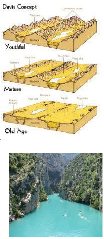
Diagram showing all the parts of river is known as
‘Long Profile’.The first part is known as the Upper Course or Mountainous
Course or youthful stage. Second part is known as Valley Stage or mature stage
or Middle Course. Third part is known as Plain Stage or old age or Lower
Course. The river course from source toits mouth is known as River Valley which
may attain a depth ranging from some meters to 500 meters and even more than
that.
1. The Upper Course/Mountain Course/
Youth Stage :
It starts from the source of river. River flows from steep gradients to low
gradients. In this part velocity of river water is high, erosion and friction
power is also high. River carries the debris formed by weathering. Various
stones roll on the sea bed and moreover friction between these
moving rocks results in formation of round shape
rocks. Gravitational Pull and Rain water plays an important role at this
part/stage of river. Rain water starts flowing downwards because of
gravitational pull.Because of “down cutting’ erosion process at this stage
various landforms are formed.The process of ‘land form’ formation is high in
areas having soft rocks and in mountains
rocks are hard therefore down cutting is possible.
Down cutting forms tight steep-side vallies and gorges.
Gorges/Canyons : Rivers like Satluj, Indus,
Brahmaputra, Gandak, Kosi etc. form gorges in Himalayan mountains. In dry
areas, canyons are formed by rivers. Canyons like letter ‘I’ and these are
steep and narrow. Canyon made by Colorado river in U.S.A. is one of the finest
examples. This is the largest canyon of world. Itis 480 kilometers long, 1828
kilometers deep and 6 to 16 kilometers wide.

(ii) V-Shaped Valley :
Mostly the rivers formed ‘V’ shape valleys.Because of high rainfall, along with
down cutting erosion, sides are also eroded. Due to this narrow valleys look
like letter *V’ with the passage of time they become wider. We can easily
understand this process from the figure.

(iii) Water Falls :
River water flowing through a steep gradient area and falls from vertical
gradient at high speed/velocity is known as water fall. Shiva Sundram (91
mtrs)and Jog (260 mtrs) on river Kaveri, while Dhuandhar (9 mtrs) on river
Narmada are famous water falls in India. At me water from the fall lands on
soft rock creating a
deep on the spot.

Do you know ?
Where are Niagara Falls and Victoria Falls are
situated.
(iv) Rapids :
These are the reactions of ariver where the bed has a relatively steep
gradient,causing an increase in water velocity and turbulence. When a
river flows through an area of alternating bonds of
resistant and

less resistant rocks, the less resistant rocks are eroded more quickly. Therefore, the soft rocks are at lower level compared to hard rocks which results in river falling in series of step along the bonds of hard rocks to form ‘rapids’. Rapids which are in a series of very short and fast falls are known as cascades. River Nile is a good example of rapid formation.
(v) Pot hole :
When river flows it creates holes of various sizes. Some rocks are soft and
they get eroded easily, resulting in deepening of holes. When water fills in
the holes new landforms called ‘Pot holes’ are formed. They have ‘cylindrical’
shape and sometimes they look like ‘discs’. Their diameter may vary from
centimeters to meters and they may be upto a few meters deep.These are
considered very dangerous

because it is very hard to come out of these deeps. Because of this, these are
also known as ‘Devil Punch Bowls’.
2. The Middle Course :
As river enters in plains from mountains, it starts deposition along with
erosion because the volume of water 1s high but velocity decreases. This
process results in formation of various landforms:
(i) Alluvial Cones :
As the velocity of river decreases, its transportation capacity also decreases.
Due to this decline deposition starts in Foot Hills. This deposition forms
Alluvial Cones. This is the first landform/pasture which a river makes with
deposition.Mostly the Alluvial Cones have stones, rocks and sand (coarse
debris).

(ii) Alluvial Fans :
While passing through alluvial cones, river is divided into various channels
and alluvial cones convert into alluvial fans. Their size varies from some
meters to various kilometers and they have semi circular shape. Cedar creek
alluvial fan of
U.S.A. and Kosi Megafan are its best examples.
Alluvial fan of nver Kosi 1s situated in foot hills of Himalayas and it is 151
kilometer long and 143 kilometer wide. Kosi river has recorded a continous
westward shifting of around 113 KM in last 228 years.
(1) Alluvial Plains :
These plains are formed by deposition of soil by rivers. Rivers bring soil
particles of various rocks. With the continuous deposition of these soil
particles layers are formed which further forms the fertile alluvial plains.
(iv) Natural Levees :
With the continuous depositon of soil on the banks by the nver,the level of
banks nses and they look like natural dams. These dams might rise upto 2
meters. Sometimes artificial Levees are also formed for the protection from
floods.

(v) Flood Plains :
“A flood plainis a feature of low relief build adjacent to
stream channel by the unconsolidated material
derived from the related niver’’.In simple words, itis because of floods that
layer of soil is depostied on the low lying areas near to the river. With the
repetition of this process flood plains are formed. This process of flood
plains formation is repeated annually,bi-annually or tri-annually.

3. Lower course of the river :
At this stage river flows very slowly and almost there is no erosion and
friction procedure. At this stage river starts deposition on its bed because of
this the level of these parts rises. At this stage river meets its mouth
forming
follwoing land forms :
(1) Ox-bow Lakes and Meanders : Word ‘Meander’
1s basically related to Turkish language which means “small windling river’ . A
river never flows completely straight,it flows in ‘S’ shaped (meanders). At low
gradients, the deposition process is very common and width of river also
increases. Due to obstacle in its way, river take turns
with which meanders are formed.

Mississippi river of U.S.A., Ganga of India and Po
of Italy are famous for
“meanders” and *ox-bow’ lakes.
An Ox-bow lake is a U-shaped body of water which is
formed when a river
creates a meander, due to the erosion of bank
through abrasion. After a long period of time, meanders become very curved and
eventually the neck of the meander becomes narrower and the river cuts through
the neck during a flood, cutting of the meander and forming an ‘ox-bow lake’.
(11) Braided Stream : According to
Miller, “A braided stream 1s one which does not flow in a single definite
channel but rather a network of everchanging, branching and reuniting channels.
At lower course, river starts depositing soil onits bed. Continuous
deposition forms soil layers. Because of this river
is divided into small channels. With further deposition small ‘Bars’ or
‘Islands’ are formed which results in formation of

(i1) Delta : Greek historian
‘Herodotus’delta of river Nile (Egypt) for the first type. This delta resembles
the fourth word of Greek language i.e. “A’.
When river flow reaches at its *mouth’, itis divided
into various small
channels. Deltas are formed with deposition of
sediments carried by a
river as the flow leaves its mouth. Its shape look
like triangle *A’, that’s why
itis called “delta’.

The total area of Ganga-Brahmaputra delta is
1,25,000 sq. km. and is biggest
delta on the Earth. All the rivers of world do not
form deltas because for such formation, certain necessities are there :
(i) Volume of water should be high at the first
stage of river so that erosion and friction process also be high.
(i1) Some other rivers or streams i.e. tributaries
should conjugate with the main niver so that amount of debris increases.
(iii) There should not be any obstacle at first
stage of river like lake etc. so that river has a long bed.
(iv) Gradient should be low at last stage.
(v) Sea waves or Esturies should not act as obstacle
in the natural flow and deposition process of river.
The rivers which do not form delta, they form
“esturies’. This type of deltas are
formed in those rivers which have volcanic soil at
its mouth. The mouth of such rivers get submerged into the sea. No river
flowing to weatern coast of India forms delta.
Types of Delta :
(i) Estuary :
Examples are Rhine, and Amazon rivers.
(ii) Arcurate (Fan shaped) :
Examples are Nile & Niger rivers.
(ii) Cuspete (Pointed like tooth) :
Examples are Ebro & Tiber rivers.
(iv) Bird’ s Foot (with fingering
branches) : Examples is Mississippi river.
Activity :regions it passes through, and name its
mouth also.

EXERCISE
1. Whatdo you mean by Denudation? What is the
difference between Degradation
and Aggradation, explain in detail.
2. Give the answer to the following in
60-80 words.
(a) Physical weathering
(b) Oxidation
(c) Biological weathenng
(d) Erosion
(e) Effect of human activities on weathering
(f) What do you mean by weathering ? Explain in
detail.
3. Answer the following questions in a
sentence or two :
(a) Whichis the largest delta of the world ?
(b) Whichis the largest canyon of the world ?
(c) From where the word ‘Delta’ and ‘Meander’ have
been derived ?
(d) What is the length and breadth of alluvial fan
of river Kosi ?
(e) What is known as delta, write with example ?
4. Write the answer of the following in
detail :
(a) Whatis the first stage of nver and which land
forms are formed at this stage?
(b) What is the effect of river on topography during
the proces of deposition?Explainin detail.
(c) Write in detail about the factors effecting
erosional work .
5. What is the difference between the
following :
1. Waterfall - Rapids
2. Alluvial Cone - Alluvial Fan
3. Reservoir - Natural Levees
4, Flood Plains - Delta

Glaciers are the important source of denudation. If
we look at history of the
Earth, we find that thousands of years ago, during
Ice age, 20% part of Earth was covered by glaciers which has confined to only
10% part now. Global climate change is responsible for this. About 96% part of
glaciers of the world is found in Antarctica and Greenland only. In Antarctica,
thickness of glacial ice varies from 1500 meters to
4000 meters.
According to the research of NASA, the temperature of
Antarctica has been
increasing by 0.12° per decade in last 50 years,
owing to this, the layers of ice sheet are breaking continuously. This activity
has resulted in rise of sea level by 73 meters.
Glaciers are found in mountains or near to high
latitudes or at poles because
temperature at these regions is below freezing
point. These regions receive snowfall continuously even in shape of snow
flakes. Because of continuous snowfall and low temperature the lower layers of
snow get hardened and is known as glacier.
Most of the regions in our world receive snowfall in
winters. Snow melts
because of high temperature and when snow starts
shifting because of rise in
temperature and melted parts start moving that is
known as glacial movement.

According to Penguin Dictionary of Geography, “A
glacier 1s an extensive body of land ice which exhibits evidence of downslope
movement under the influence of gravity and which forms from the
recrystallization of neve and firn.”. Holmes has defined glacier as “masses of
ice which, under the influence of gravity, flow out
from snowfields where they originate”’. It makes
clear that only a huge piece of ice/snow is not a glacier, nor is that frozen
huge only which melts at increase of temperature.

Lious Agarriz proved in 1834 that the central part
of glacier moves faster than its sides.
Transformation of Snow into Glacier :
At snowfall, snow is very soft single ice crystal or
aggregation of ice crystals is known as snowflakes. with the continous process
of combination of flakes, formation of granular snow begins. Water vapours
start turning into solid form and low temperature helps in unifying of (firn)
crystalized ice which further takes form of hardened snow. This is known as ice
of glacier. Pores disappear at this stage and when this ice starts moving its
solid form puts effect upon its speed also .
Sometimes it takes years to form of snow flakes firm
and transformation of
snow into glacier may take three to five years.
The speed of glacier depends on the
following aspects :
1. Bigger the size of glacier, faster it will move.
2. Glaciers may move at speed varing between some
centimeters to 40 centimeters.
3. They move fast on steep gradients.
4, Their speed is high during summer.
Snow Fields and Snow Line :-Regions
which are always covered by snow are known as snow fields.Glaciers start from
snow fields. All the continents have snow feilds except Australia.The line
above which, the rain water falls (as) in the form of snow is known as snow
line. In hot areas the height of snow line extends
upto 5000 meters. In cold areas, it is even upto sea level. This line is also
low in steep gradients of mountains.

Types of Glaciers :Glaciers
are of various types on the bases of their size and structure. All the glaciers
are divided/categorised on the bases of structure and temperature. AhImann
(1948) has divided glaciers into three categories:
1. Continental Glacier : Earlier,
thousands of years back, North Europe, Asia and northern parts of America were
covered long & wide by large glaciers but today their size has decreased.
Presently such glaciers are found in Antarctica and Greenland.Their size is
very large and they cover the whole continent. These are slow moving
glaciers.
2. Valley Glaciers :
These glaciers start from snow covered mountains (ice caps).These are long but
their breadth is less. These are also known as Alpine glaciers also.Because of
their erosion process they create ups and downs. These type of glaciers are
found in upper hills of Himalaya. The largest glacier of Indiais situated in
Siachen
(72 km) in Karakoram Mountain range. Another
important glacier of Indiais Gangotari (25.5 km-Uttarakhand). Valley glaciers
are found in mountain valleys only. World’s largest glacier 1s situated in
Alaska, i.e. ‘Hubbard Glacier’ (130 km).
3. Piedmont Glacier:
Glaciers which conjugate and form a sheet like structure at the base of
montains or in low lying areas are known as Piedmont glaciers. These are found
at high altitudes. ‘Melaspina’ glacier of southern Alaska is the finest example
of Piedmont Glacier.
Broken parts of glacier are known as ice bergs.
These are formed during calving
process. Calving is a process, in which front
portion of glacier (Snout) break from main glacier near the sea.
Works of Glacier :
Glacier is a form of hard ice, which move and expands
continuously. It can move at speed of some
centimeters in a year to 100 meters ina week. Their speed varies and it is
different from each other. Some of the glaciers reach upto the sea while others
melt before reaching there. Glaciers play animporant role in changing the
structure of land/Earth. Glaciers also perform erosion, transportation and
deposition activities. When they move they carry
stones, rocks, soil, vegetation etc.along with them. If the glacier is made up
of ice only then its erosion capacity is nil. On the other hand glaciers having
debris perform erosion activity more abundently. The
erosion process by glaciers is carried out in
following ways :
(1) Plucking or Quarrying :
This is the process in which glaciers move the rocks broken by weathering from
one place to another. This activity is more vibrant at leeward slopes i.e.
slopes facing away from the direction of ice movement.
(ii) Abrasion :
Glaciers get power of erosion and friction when they carry debris with them.
Big rocks move beneath the layers of ice and with the movement of glaciers
these big rocks performs the friction acitivity on the banks and bed of valley,
resulting in the increase of depth and breadth of valley.
(iii) Attrition :
This is a process in which size of broken rocks decreases, because of their
friction with each other or with Earth. Such frictional activity is called
attrition.

Following land forms are formed due to the
erosion process of
glaciers :
1. Crevasses : When a glacier moves, the speed 1s higher at central part as compared to its outer parts i.e.sides. The path on which glacier moves eroding it while moving, is known as pavement. During its movemet as glacier approaches some higher hindrance, it climbs over and then proceeds climbing down.

In this process the
upper layer of glacier develops vertical cracks which expand with passage of
time. Such cracks are known as Crevasses. As a glacier proceeds further average
or steep slope, these crevasses enjoin each other and glacier takes smooth
form. These crevasses are very dangerous for tourists, because when these are
covered by fresh snow, no one can judge that they might be 2 meter broad and 50
to 200 meters deep.
2. Cirque :
‘Cirque’ is a word from French language. If pits are formed by rivers on steep
gradients, their size is increased by erosion process of glaciers. Further they
are filled by ice and hence known as ice reservoirs. Their shape looks like
‘resting chair’ .
These are also known as Berg-Schrund. Their size
increases further because of
freezing of ‘Frost’ and Snow. Sometimes a lake is
formed in the centre of cirques,known as Torn. ‘Cirque-de-Cavernic’ is the
world famous cirque. In Scotland, cirques are known as ‘Corrie’, in Germany as
‘Karren’, is Norway as ‘Cron’ and in Scandenevia these are known as ‘Kessel’.

3. Horn:
As ice accumulates in a cirque at a particular height and takes form of huge
ice reservoir, the breadth of cirque increases because of freezing of ice,
resulting in erosion of rocks which fall in its path. In such conditions, sides
of central point erodes and only the central point is left uneroded, which
looks like a “horn’. ‘Matter horn
Peak’ of Switzerland is the finest example of horn.
When the ice of horn melts, a steep rock appears which is known as ‘Nunatak’.
These forms are found in Greenland and Antarctica.

4, Col or Pass :
When cirques are formed on both sides of mountain, some part of
central Ridge also falls down with passage of time
forming way/path whichis known as “Pass”. In Alpas mountains various passes
have been formed by glacial activity.These are used for transportation
purposes. ‘Indira Col’, situated in the nothern India,
has big strategic importance for India, Pakistan,
Afghanistan, Tajakistan and China.
5. Comb Ridge or Arete :
When, on the both sides of ridge of the mountain, cirques have formed several
horns and they look like Comb, that 1s known as Comb Ridge.Sometimes tips of
high mountains also look extremely sharp and are known as Arete.
6. U-shaped Valley :
When glacier moves in a pre-formed valley, the breadth of
valley increases because of the erosion by the
glacier. Due to this process valley looks like the shape of Roman alphabet *U’.
That is why it is known as U-shaped Valley.
7, Hanging Valley : Like rivers,
glaciers too have tributaries. Main glacier increases the depth and breadth of
its valley, the other glaciers moving towards this valley conjugate with main
glacier, and form a steep gradient. After melting of ice, the level
of valley formed by main glacier decreases as
compared to that of glacial tributaries.Tributaries conjugate with main glacier
as ‘fall’. In this situation valley of tributary seems to be hanging in the
valley of main glacier. Itis known as hanging valley.
8. Sheep Rocks or Roche Moutonnes :
“Roche Moutonnes’ is a word of French
language which means ‘Fleecy Rock’. Sometimes there
are big rock forms in the path of a moving glacier, which cannot be broken
easily. Glacier moves up on this rock and with erosion and friction,decreases
its height without stopping at this point. This whole process results in the
leveling of the

windward side of rock and the leeward side becomes
rough and steep. Due to this it looks like a sheep and is known as ‘Sheep
Rock’. From a distance it looks like back of a sitting sheep.
Transportation
Glaciers carry rocks, stones, soil, vegetation etc.
along with them. The erosion process of glacier depends upon the debris it is
carrying. Glacier performs the task of transportation in several ways. Debris
comes on the surface of glacier because of weathering. The heavy part of debris
moves down through the cracks. Due to the formation of other layers of ice on
the top heavy debris keeps deposited in the lower layers but it also moves with
the movement of glacier while moving various types of erosion and friction
process are carried out by the glacier. Glacier can move heavy rocks weighing
upto several tonnes, from one place to another.Depositional work of a Glacier :
As glacier melts or stops moving, it deposits the debris on the surface and its
sides, which is known as glacier drift. When glacier looses
its capability of carrying ‘glacier dnift’, the
debris is deposited which results in formation of various land forms :—
1. Moraines :
On melting, glacier deposits its debris in the form of a
heap. Rocks deposited are not uniform, and are of
several types and different colours e.g. Soft rocks, which are also known as
glacier flour, triangular shaped pieces, big rocks, whose diameter varies from
some centimeters to 20

meters, are found in this debris. This debris is
known as Till or Morains.
Following are the types of Moraines :
(a) Lateral Moraines :
When pieces of rocks are deposited on the both sides of the glacier and are
sometimes higher than even 100 feet. This form is known as Lateral Moraines.
The thickness of moraines in Alaska, extends upto 350 meters.
(b) Medial Moraines : When two
glaciers conjugate, the moraines of their sides also conjugate forming a single
moraine. Huge variation is found in the width of these moraines.
2. Esker :
Sometimes, ice melts at the lower parts of the glacier and water starts flowing
beneath the ice forming tunnels in the glacier. Debris gets deposited in these
tunnels. With the passage of time both water and ice disappears, leaving behind
the debris in the shape of long lines. This is known as ‘Esker’. Its length
varies from 10
meters to 100 kilometers and their breadth also
varies from some meters to kilometers.These are found in Finland, Sweden, North
England and Scotland.

3. Kettle Holes : When glacier
moves, pieces of rocks or stones fell on it. After sometimes with the melting
of ice, small holes are formed in glacier. These holes are known as ‘Kettle
Holes’. These are found in North American Prairies.
4. Kame : When glacier
melts, the soil and other items of debris deposited in the cracks, get
deposited in form of mound. Itis known as Kame. Examples of these are found in
the parts of Scotland, Finland and Canada.

5. Outwash Plain :
When a glacier passes through the ice tunnels and deposits the
sediments at a distance or in simple words when a
glacier make its last moraine, the melted part of the glacier takes away light
soil and deposits it in the form of layers and such deposits attain the form of
plains. This is known as ‘Outwash Plain’. This particular name is given to this
landform because all the material has been taken from
the last moraine. In Icelands these are known as
‘Sandur’.
Are we still living in ‘Ice Age’ or it has been
finished ? (The time Period of 25 lakh years ago is accepted as “Ice age’).
Presently also, the region covered with snow/ice give us the answer ‘Yes’. But
if the human activities continously act as areason behind the melting of ice
then definitely we will loose the glaciers. Global warming and
Green house gases are major cause of melting of ice.
In India, Himalayan mountains are house of snow.
Total area of Himalayas is
5 Lakh Km? out of which 33,000K m? is covered by
snow. This mountain region has 15,000 glaciers ‘Siachin’ glacier which is
situated in Nurba valley, is the largest glacier (after poles). It covers the
area of 450 sqaure kilometers. Gangotari glacier is the
source of river Ganga. Baltoru and Godwin Austin are
also big and important glaciers.
Activity ;Write the names of seven biggest glaciers
of the world and paste their pictures in your note book.
EXERCISE
1. Answer these in a sentence or two :
(a) Whichis the largest glacier in India?
(b) Whichis the largest glacier in the world ?
(c) How much area out of total areain Himalayas 1s
covered by glaciers ?
(d) Where is ‘Indira Pass’ situated ?
(e) What is the increase rate of temperature of
Antarctica per decade ?
2. Explain the difference :—
(a) Lateral — Medial Moraines
(b) Drumlines — Esker
(c) Cirque — ‘U’ shaped valley
3. Give the answer to the following
questions in detail :
(a) What is a glacier and what are its types ?
(b) Glacier is animportant source of denudation. How
?
(c) What forms come up with alluvial deposition of a
glacier ? Write in detail.
(d) What are the landforms that take shape by
erosion process of glaciers,
Explain.
iii) Denudation Works of Wind
Air moves because of atmospheric pressure and this
moving air is known as
wind. Winds blows because of vanations in air
pressure. Wind always blows from high pressure to low pressure. The direction
from which wind is coming gives it the name of same direction. Winds perform
denudation activity also but their erosion and transportation capacity is low
as compared to water. They work well in dry and desert
areas. Desert areas receive rainfall less than 25
centimeters annually and have high temperature. Because of these conditions
these areas do not have any vegetation and moreover there are not many
obstacles in the flow of wind. Most of the deserts of the world are situated on
the western side of continents (20° to 30° N & S latitudes). The south
western semi-arid part of Punjab also resembles to desert region. Winds helpin
the process of denudation in desert areas generally
because of following reasons :
(i) Deserts are completely different to moist
regions. Chemical weathering is common in moist or wet areas but in dry areas
only regional weathering is possible. ‘Salt wedging’ is one ofits example.
(ii) Desert regions which receive low rainfall and
have low vegetation, help winds to carry out denudation process easily.
(iii) Large regions in deserts are impermeable
because of which the underneath layer of Earth has no moisture.
(iv) Deserts which have high soil content, expand
because of heavy winds and scanty rain. Their size increases continuously.
(v) Most of the rivers of such regions are seasonal
or ephemeral. They flow during rainfall sessions and for short span of time.
So, because of less rainfall, vegetation in desert areas is very less and winds
feel free play important role in denudation process.
Only thorns and shrubs are found in desert areas.

On the basis of erosional and
depositional works by winds, deserts may be classified into three types :
(1) Soil Desert :
Sand in the major constituent in such deserts. Wind easily
transports sand particles. In Sahara, these are
known as *Ergs’. In Turkmeinistan,these are known as *Koun’. The biggest erg is
situated in Khalis, Saudi Arabia. Its area is 5,60,000 sq. km.
(2) Stony Desert :
These are formed by rocks, stones etc. Reg in Algeriais its finest example.
(3) Rocky Desert : These are barren regions, where the upper soft layer vanishes,leaving behind only rock heights/rocks and barren land. Hammada (Barren Bed Rock)in Saharais its example. Its name ‘Hammada’ also originates from Sahara.

Sahara is the
largest desert of world which is situated in Africa. Thar desert of India is a
hot desert which includes parts of Rajasthan, Gujarat, South West Punjab and
Pakistan (Punjab and Sindh). Some cold deserts are also found in Central
Asia.Atacama desert of South Africa is the driest desert of world, it receives
annual rainfall less than 1mm.
Wind Erosion : Like other means of denudation, winds
also perform erosion and friction activity. Winds carry rock and soil particles
from one place and when their speed reduces they deposit those particles.
Erosion process may be divided into three stages:
1. Deflation :
High speed winds pick up soil and rock particles, resulting in the decrease or
shrinking of upper layers. This process is known as deflation. Sometimes due to
this process hollows are formed, which are mostly small in size but their
diameter
may extend from 1 to 15 kms.

2. Abrasion :
High speed winds carry soil and rock particles, small pieces of rocks etcs.
This debris act as ‘sand paper’ and performs erosion and friction activity on
other rocks which is known as abrasion. These are also known as tools of wind.
3. Attrition : Sand particles
carried by winds, start friction process with in itself and because of this
their size reduces. This is known as attrition. Erosion process of high speed
winds is also fast.Soft rocks break down easily but on the other hand erosional
process is long in case of hard rocks. Small particles are transported upto
long distances but big rocks and stones (of 5 to 8 centimeter radius) cover
only small distance. Wind erosion results in
the formation of various land forms, which are as
follows :
1. Oasis :
During deflation the upper layers of stones are eroded by high speed winds and
rocks having water appear on the surface. Because of this underground water
oozes out (comes out) which is known as Oasis. Any type of vegetation and human
life is possible around oasis. These landforms are found in desert regions of
Algeria, Libya
and Thar in India.
2. Needles : Complete to
erosion of soft rocks by high speed winds allows steep
gradient rocks stand uneroded and still. They look
like needles and therefore known as rocky Needles.
3. Mushroom or Pedstal rocks : Wind erosion
takes place at the average height of 1 meter from the Earth’ s surface. While
above height of average 2 meters,erosional process is again very
low.Resultently middle portion of vertical rocks is eroded by high speed winds
and after erosion rocks look like

mushrooms. In Sahara desert such land forms are known as ‘Gaur’ and in Germany these are known = as
Pitzfelsen’. In India, these are found in
‘North-West’ Jaisalmer (Rajasthan)
generally.
4. Zeugen : *Zeugen’ is a
word from German language which means “Like Table’.When soft rocks covered by
hard rocks are eroded by winds, hard rocks left behind looks like table and
known as *Zeugen’. Their length may vary from 1 meter to 30 meters. Along with winds,
rainfall and weathering also help in formation of *“Zeugen’.

5. Yardangs :
Winds blowing continuously in one direction result in the erosion of zeugen in
one direction/side only. Zeugens are eroded much from winward side and less
from leeward side. This process forms a very queer structure of these rocks.The
ratio of these structures (length and breadth) varies from 3:1 and 4:1 and
average height is around 8 meters.In India such landforms are found in
Jaisalmer (Rajasthan).
6. Stone Lattice : At times rocks
are formed by the combination of both
soft and hard types of stones. Soft rocks and soft
parts of such formations get eroded by winds and only hard parts are left
behind which make formations look like ‘net’.These are known as Stone Lattice.
7. Driekanter :
The direction of winds is never fixed and in the absence of vegetation in
adesert, various rocks get eroded continuously in the direction of wind. With
such continuous and all directional erosion, rocks attain a triangular shape
and these are
known as Driekanter.
8. Window & Bridge :
Continuous erosion by high velocity winds forms
holes in the rocks. Such holes are called Wind
Windows. Further, the combined action of deflation and abrasion makes the wind
windows larger and wider which assumes an arch like shape with solid roof over
them. Such land forms are called Wind Bridges.

9. Demoislle :
Some hard rocks are wrapped all round by soft rocks. With the continuous wind
erosion soft rocks get vanished leaving behind the hard rock, which looks like
a pillar. This pillar formation is known as Dermoislle.
10. Lag Deposits :
Fast blowing wind carries lighter particles like sand, small pebbles and stones
with it. While heavier stones and other big particles lag behind. These
particles look like a layer of heavy stones and rubble. Such layers are very
commonin desert regions. In Sahara desert such lag deposits are known as
‘Hamada’ in local language.
11. Inselberg :
Wind erosion makes desert appear/look like plain but at some places some small
mountains of solid rocks are found. These mountains are kwnon as Inselbergs.
Mt. Aabu (Graynite Inselberg) and Sendra near Pali are the finest examples.

Transportation by Winds : Wind transports pieces of
rocks, soil, stones etc., like rivers and glaciers, from one place to another.
Although winds erosion is less effective as compare to that by rivers but it
may be seen clearly in deserts. Transportation of particles takes place in
different ways. High velocity winds can transport heavy debris from one place
to another but on the other hand slow speed winds transport light weight
particles only. Sometimes heavy and large pieces of rocks are not picked by
winds but they roll on ground along the wind direction.
A dust storm having diameter of 500 km can pick up
100 million (10 Crore)
tons of soil. It has a capacity of forming a 30
meters high mountain with a base of 3 kilometers. Delhi experienced a dust
storm on November 14, 2014. Its speed was 90mph and resulted in loss of life
and property. Thick dust storms in Thar, sometimes reduce the visibility to
hardly three feet and the particles being transported by such storms cause
heavy losses also. The size of particles moving with high vilocity winds
decreases because of friction produced in itself.
When the speed of wind decreases,debris starts depositing.
Shifting of Sand Dunes : Direction of wind is not
fixed because of this sand dunes are not stable, they shift according to the
direction of wind. Shifting sand dunes is harmful
for fertile plains. Fast growing and deep root
plants are planted in desert regions to control this process. They may shift
from 5 to 30 meters per year.
Depositional Work of Wind :
Deposition work of wind may be divided into two parts namely :
1. Sand Deposition and
2. Clay Deposition.
(1) Sand Deposition :
Following landforms comeup under this head :—
(a) Ripples : Low speed winds
deposit the particles in the shape of waves, which are known as layers of sands
or sand ripples.The inter-difference between these waves may vary from few
centimeters to few meters. The windward side of Ripples is generally angular at
8° to 10° while leeward side is angular at 20° to 30°. Their height rises to a
few centimeters only.

(b) Sand Dunes :
Velocity of wind carrying sand decreases when it faces
some obstacle and therefore wind it starts
depositing the sand particles on the spot of obstacle only. Resulting in the
formation of sand dunes. Any shrub, big rock, skeleton of an animal, upland
area can act as such obstacle. The height of sand dunes may vary from some
meters to 150 meters and their length may vary between 3 kilometers to 150
kilometers. Sand dunes may be of
many types :—

(1) Barkhan : Half
moon and crescent shaped sand dunes are known as Barkhans.
These are convex on windward side and steeper and
concave on leeward side. They might be high upto 30 meters and their length
varies from 150 meters to 200 meters.

(ii) Seif or Longitudinal Sand Dunes :
Seif is an Arabic word which means ‘Sword’.These sand dunes are generally
oriented in a direction parallel to prevailing wind but when the dunes blow
out, sand gets deposited in parallel forms. These may raise to 100 meter high
and their breadth varies from 500 to 600 meters. These are not shifting sand
dunes. These are found in areas where high velocity
winds blow. These are foundin Sahara Desert (Africa), Thar Desert (India).
(iii) Coastal Dunes : High velocity
winds blow in coastal areas because of this, waves deposit sand on the coasts
of oceans. Blowing wind gives it a form of “Sand Dune’.With the growth of
vegetation in these areas, curved sand dunes are formed and sometimes they also
look like Barkhans. These are found in Atlantic coastal regions. In Southern
France, there is 240 kilometers long dune along the coast covering 3 to 10
kilometers in inland areas. On the Western coast of
India, sand dunes (coastal areas) of Goa are famous for their beauty.
2. Loess Plains :
Winds deposit light and soft soil over a large area like a blanket,these are
known as plains of Loess. ‘Loess’ is a word of German language which means
yellow colour, porous soil with very soft particles. Generally, these particles
are
of same size.This soil does not have layers and itis
frable. When we press it crumbles easily. During rainfall it becomes very
sticky, on the other hand in summer it becomes very dry. Loess is found in
China, Europe, North America, South America and Africa.The name “Yellow river’
in Chinais also given on the basis of their soil because when
it mixes with river water, water appears to be yellow in colour.

Wheat and Maize is grown in Loess plains and more over soil erosion is also very (low/less) in these plains. In India this soilis found in Kashmir andin Pakistan itis found in
Potwar plateau.
Activity :
Show the ‘Thar Desert’ in the map of India
Make a model of Landform that is made by winds.
EXERCISE
1. Answer the following in few words
only :
(a) Whichis the largest desert of world ?
(b) How many types of deserts are there ? Wnite
their name also?
(c) Whatis an ‘Arg’ ?
(d) Are the sand dunes always stable ?
(e) Whiatis the colour of Loess soil and which crops
are grown in this soil?
(f) Whiatis the difference between air and wind ?
(g) What do you mean by porous rocks ?
(h) How the coastal sand dunes are formed ?
2. What is the difference between the
following :
(a) Barkhan — Loess
(b) Stone Lattice — — Driekanter
(c) Zeugen —_— Yardang
(d) Oasis — __Inselberg
(e) Rockydesert — Stony desert
3. Write the answer of the following in
100 words :
(a) Winds are the source of erosion in deserts,
Explain.
(b) Which are the landforms that are made by soils
during erosion process ?
Explain.
(c) Write in detail about the deposition process of
winds.
(iv) Denudation works of Underground Water
Water
plays an important role in changing shapes over the land although. Its amount
is not uniform at all places. At some places it is found an abundance and at
other its quantity is very small. When Surface water seeps into Earth through
porus rocks, itis known as underground water. Although flow of underground
water is similar
to that of overground water yet, the speed of flow
of underground water is too less and because of this its geographical
weathering activity is also low while chemical weathering activity is high.
Moreover, clean water does not involve in any activity but while seving into
Earth various chemicals get mixed init. We find the work of underground water
in the regions with rich chalk, Limestone and Dolomite contents.

A geographical distribution of the location of water
on earth :Works of underground water are not much visible on the upper layer of
Earth.Mankind extracts it out to fulfill their various needs. e.g. Agricultural
and house hold,
etc. Sometimes it naturally comes out from Earth
through natural openings like springs,wells, Geysers, etc.
[fin any region, rainfall is high and rate of
evaporation is low then the level of underground water will be high.
(A) Springs : When the water
oozes out naturally from Earth1.e. on the upper and outer most surface, that
flow is known as ‘spring’. Mostly springs are found at the junction or fissures
and joints of Porus and Nonporus rocks. In India these are found inhilly
regions of Jammu Kashmir, Manikaran (Himachal Pradesh), Bihar and Assam.
There are various kinds of springs :
(i) Hot water spring / Thermal water
spring : These springs have hot water and are found in
volconic regions. In Himachal Pradesh, langar is cooked with the help of heat
generated by such springs at Manikaran Sahib.Indiais planning to install its
first geothermal plant, which will produce power upto
3to5 MW.
(ii) Cold Water Springs : These springs
provide cold water and are mainly found in Himalayas, Western Ghats and
Mountains of Chhota Nagpur Plateau.
(11) Mineral Springs :
These springs have mineral and salts in their water. These are very helpful in
the treatment of skin discases. Such springs are found in Manikaran,Manali
(District Kullu), Sahashtradhara (Dehradun), Tilsma Rajasthan when water flows
continuously from a spring, itis known as Permanent spring.
(iv) Geysers :
When lots of steam oozes out as fountain alongwith hot water, such form is known
as geyser. These might raise 30 to 60 meters high. The old faithful geysers of
Yellow Stone National Park, Situated in Rocky Mountains of USA, comes active
for four minutes after sleeping for 65 minutes at average. Iceland, parts of
Rocky
Mountains of USA, North Island of Newzealand and
Yellow stone park of wayoming state in USA are known for Geysers and Hot water
springs. Total number of geysers in the world is 425 and out of these, 225 are
situated in Yellow Stone Park of (USA America) This region has 24000 springs of
hot water and around 100 geysers.Some Geysers continuously ooze out on the
Earth’s surface and their temperature is 100°C (or 212°F). Some Geysers collect
very less debris and some of them make acone like nozzle. Most of the Geysers
spread mineral deposits on the area around
them.
(B) Well :
When underground water flows beneath the surface through a hole, that
is known as ‘well’. If the well is not deep then the
water does not come out
continuously and that is known as “Intermittent
well’

(C) Aquifer :
This is a word of Latin language which means ‘to bear water’. An underground
permeable rock is present which contains water and = an impremeable rock is
situated below the permeable rock, thus a reserviour of underground water is
created. “Aquifer” is a natural filter which purifies various types of
sediments and bacteria. ‘Aquifers’ get pollutedif waste material is thrown in
them and moreover septic tanks, medical waste (Injections, Medicine),
Fertilizers etc. also create problems if constructed or piled near the
aquifers.
(D) Artesian Well :
The word Artesian has been derived from the word * Artois’,which was the name
of a province of France where first Artesian well on the Earth was dug in 1126.
Itis a limited Aquifer in which water comes out through well because of
pressure even without using a pump. Great Artesian basin is the world’s largest
and
deepest Artesian basin, which extends over 23% part
of Australian continent. Australia has 9000 Artesian wells, maximum in the
world. In India these are found in Indora Tehsil of District Kangra (HP),
Mukenan Tehsil of District Hoshiarpur (Punjab), Tarai,Pudduchery, Tamilnadu,
Alluvial soil areas of Gujrat etc.Underground water as an agent of denudation
Underground water also performs erosion, transportation and deposition
activities.The speed of underground water is very low. If “KM/Hr’ unit is used
for speed of river
then ‘meter per day’ is used for underground water.
Because of this its activities may be seen only in regions having soft rocks or
regions with Limestone, Dolomite etc. As
topography, underground water forms “Karst
topography’ in areas which have
limestones. In India this is found in Chirapoonji,
Jammu-Kashmir, Himachal Pradesh,Panch Marhi (M.P.), Bastar (Chattisgarh and
Coastal areas near Vishakhapatnam.
Karst means barren land. This word has been derived
from Kars or Kua, which
is a plateau region situated in Slovenia (former Y
ogoslavia).‘Karst topography’ is also found in the areas having Dolomite,
Gypsum or Halite,(Rock-salt).
Following land forms are formed by
denudation activity of underground water :
1. Lapies : In German language these are known as *Karren’ and in English these are

known as ‘clint’ while Lapies is a french
word. When underground water contains Carbondi oxide init, dissolving process
of ‘lime stone’ rocks begins. Because of this breadth of cracks and joints
increases, which are known as “Lapies’.

2. Sink holes : Sometimes Lapies gets deep like
funnel forming a sink hole. Its depth may vary from a few centimeters to some
meters.
3. Swallow holes : When the size of sink holes
increases, these are called swallow holes.
4. Doline : Due to high chemcial activity on swallow
holes, their size and depth increases. Its diameter may extend upto some
kilometers and depth may run upto 100 meters. Mostly such forms are found in
tropical regions.
5. Karst Lakes : When the lower part of Dolite is
blocked because of debris formed by its own erosion, water gets collected as
reservoir. This is known as ‘Karst Lake’.
6. Uvalas : A reservoir is formed with the
conjugation of many sink holes. This is known an Uvala.
7. Ponar : When Uvalas are filled with water, high
erosion activity converts it into a tunnel like structure, which is known as
ponar.
8. Caverns : In lime stone regions the flow of
rivers are not outwards but is inwards.it dissolves its own bed and forms a
large cave called ‘cavern’. The roofs of such structures are called Chambers.
In India these are found in Chattisgarh and Chirapoonji.
9. Natural bridge : When roofs of caverns collapse,
some of its parts are left behind,which look like a bridge. This is called
natural bridge.
Depositional work of Underground Water
:
Underground water dissolves the rocks but when it
deposits this dissolved materials various types of forms are created :-
1. Stalactite and Stalagmite : These are fromed in a
region nch with lime stone,
where caverns have been formed. Lime water seeps
down-ward from these caverns
during this activity some of drops hang with the
ceiling of cavern. Due to evoporation,water gets evaporated and the hanging
structure of lime is left, which is known as *stalactite’. Its breadth is more
near the ceiling as compared to its tip.The drops of lime water which fell on
ground, get evaporated and only a structure
made of lime is left behind. This is known as
‘Stalagmite’. Its width on the ground iS More as compare to its tip. Sometimes
both stalactite and stalagmite combine to form a pillar which gives an
impression of acavern on the whole. “Zenolan lane’ in Sydney (Australia) is its
fine example whichis around 100 kms deep. Another natural cave or cavernis at
Tirlokpur falling on Pathankot-Dharmshala Highway, which is thousands
of years old.China, India and USA are top three
nations which use underground water for agriculture the most. Central Ground
Water B oard, established in 1970, has carried out 21 pilot projects to
recharge the underground water artifically in Amritsar,Jalandhar, Patiala and
Sangrur districts of Punjab.
Underground water is very important and it must be
used properly. In Punjab the level of underground water is decreasing day by
day (continuously). Its level is extremely down in 85% part of the state. Low
rainfall is one of the pn mary reaons behind the situation. Annual average
rainfall has been decreased upto 45-50%. Annual rainfallin 1990 was 755 mm.
which has come down to 375 mm in year 2004. In 2009 it was 420 mm and in 2014
it was recorded 600 mm.Cultivation of ‘Rice’ is another reason. Rice is planted
on 2/3 part of Punjab before
June 15 ever year, which increases the need of
irrigation and moreover during this period evaporation is also fast due to hot
weather. In these conditions underground water is used to fulfill the
requirement of water, Around 73% Irrigation depends on the underground water
and all this has resulted in banning of use of underground water
at a few places. Hence it is our duty to use
underground water properly.ctivity ; What can we do to save underground water
for our future generation’Discuss this in the your class with the help of your
teacher and also collect the information about the number of wells and
tubewells in your area.
EXERCISE
1. Give the answer to the following
questions in one or two words :
(a) In which State of France, first ever Artesian
well was dug ?
(b) Write the names of hot water springs of Kullu
Valley.
(c) Inwhich country ‘Old Faithfull Geyser’ is
situated ?
(d) At which places of India, cold water springs are
found ?
(e) What was the Annual/Monsoon rainfall of Punab in
2014?
2. Write the answer of the following
questions in detail :-
(a) Underground water is a source of denudation,
How? Write in detail.
(b) What is the depositional process of underground
water and what landforms
are created by this process ? Explain with
[Hustrations.
3. What is the difference between the
following :
a. Lapies - Doliane
b. Stalactite - Stalagmite
c. Well - Artesian Well
d. Geyser - Spring
(4) Denudation Works of Sea
Like river water, sea water also performs denudation
acitivity in the form of waves, currents and tides. Because of this various
landforms are formed but obviously this process takes place only in coastal
regions. Coastal regions are totally different to
non-coastal regions.
The speed and velocity of waves depends on the speed
of winds. Sea water
rises because of direction, pressure and friction of
winds. The part of water, which rises is ‘crest’ and the lower one 1s known as
‘trough’. Rocks, stones, sand, soil etc., present in high speed waves increase
the erosion capacity of waves. Sea water also performs erosion, transportation
and deposition activities.

Coastline is a place where Hydrosphere, Lithosphere
and Atmosphere meet.
Erosional work of Sea Waves: Erosional work depends
on the speed and power of
waves, gradient and height of the coast and moreover
depth of sea. Erosion process 1s not uniform at all the places.
Erosion of hard rocks is slow but incase of soft
rocks it is very fast. During
rainfall water level increases which accelerates
erosion. Plants and animals reduce the strength of rocks by making holes in
them. Presence of sand, soil, rocks, stones etc. in waves increases the
erosion. Any hindrance in the way of waves gives it the name as ‘braker waves’.
A number of braker waves when flow towards coast, these are known
as ‘surfing waves’. At times the “might” of these
surfing waves 1s to such an extent that these exert a presence of 3000
kilometers per square meter to 30,000 km per sq.meter on the costal rocks.

Waves can perform erosion activity in
four ways :
(a) Hydraulic Action: Rocks are broken when waves
having debris (rocks, soil, sand,stones etc.) strike with huge force.
(b) Abrasion: When both waves and currents break the
rocks this happens when waves strike with rocks again and again. It is a
frictional force and known as abrasion.
(c) Attrition: It 1s because of waves, when the size
of pieces of rocks decreases or they are grained, this process is known as
Attrition.
(d) Solution: Soluble rocks like limestone,
dolomite, chalk etc. dissolve in sea water.This solvent action is limited to
certain areas only.
When a wave strikes it starts erosion
process, resulting in the formation of following forms:
1. Sea Cliff: Waves erode the lower part of the
coastal rocks, first because these are at sea level. Sometimes the lower parts
of rocks are soft and get easily eroded. The upper part of these rocks look
‘high’, whichis known as cliff. It has a steep gradient.
Sometimes waves make a hole in lower part of the cliff with erosion activity, know as *notch’. The size of notch increases with the passage of me and seacaves are formed.

Cliffs situated on the western coast
of India are the finest examples.
2. Sea Caves: With the passage of time, size of
‘Notch’ increases due to erosion and a large pitis formed in the lower part of
cliff. This is known as seacave.
3. Arch or Natural Bridges: If at any coast, Waves
strike on both sides of caves and form a hole, such structure is known as sea
arch, moreover it looks like a natural bridge.

4. Stack: Natural arch collapses due to erosion,
leaving steep and often vertical columns of rock, whichis known as ‘stack’.
5. Stumps: When stacks get eroded by the waves, they
collapses, leaving behind a
stump. Stump usually forms a small rockisland, low
enough for a big tide to submerge.

6. Spouting horns or Blow holes: Due to erosion, the
cracks of seacaves form a
hole in the roof of the cave, whichis known as
spouting horn or blow hole. Actually when the water rises into sea cave,
already available air starts dashing out through the hole incave roof, creating
whistling sound. This sound gives it the name, Spouting horn

7. Breaking of Sea caves: When high speed waves
strike with huge force on cave,they create pressure on the internal air upto
such extent that cave break down into pieces. Inspite of this sometimes large
number of blow holes are formed in caves because of which it losses its
strength and collapses. With the break down of cave a narrow inlet
is formed whichis known as ‘geo’.
8. Caves: Sometimes on the coast, soft and hard
rocks are situated parallel to each other. When soft rocks are eroded faster
with the hard rocks surrounding them, small gulfs are formed which are known as
caves.
9. Creeks and Bays: When soft and hard rocks are
situated in vertical positionand continous erosion by waves erodes soft part of
these rocks resulting in formation of deep and narrow inlets known as ‘creek’.
With the passage of time their depth and breadth increases whichis known as
“Bay”.

10. Headland or Cape: Sometimes a hard rock is
surrounded by soft rocks and
erosional activity of waves leaves only hard rock
standing vertically ahead of it surrounding. Such form is known as headland or
cape.
Transportation by Sea Waves :
Waves pick up the rocks, stones, soil etc. formed by
the process of weathering and bring them in sea water. High speed waves bring
shells and other materials on the coast, people collect these for manufacturing
of material used for decoration purposes.
Shells are direct source of Calcium Carbonate and it
is used for increasing the level of calcium in the soil, manufacturing of
musical instruments, poultry feed and for making ornamens.
Depositional work : While transporting the debris,
as carrying capacity of waves reduces, debris is deposited on the coast.
Because of which various forms take shape.

1. Sea Beach : Beaches are formed by deposition of
soil, rocks, stones etc. on the coast by sea wavess. The size of a beach
depends upon the debris deposited, more the debris, larger will be the beach.
Beaches may be of various types. life curp beach,Gokarna and Kovalam, Linear
Beaches, Marina beach Chennai, Rock beaches and Sand beaches. Marina beach is
second longest beach in the world. Beach formation is possible during low
velocity of waves or swift moving wave or thunder storms destroy
beach deposits.
2. Sandbar : Sand bars are formed if sand gets
deposited parallel to the waves. These are extended parallel on the front side
of the hard rocks near the coast. When its size increases it is called as
offshore or longshore sandbar. Sometimes gulf is blocked due to the huge
deposition of soil, offshore bars which act or blockers, get combined with
each other and are known as Tied Island. The Islands
also have various types e.g. Bay bar, Tombolo, Hook, Loop etc.
3. Spit : Deposition of sand and rocks at some
distance from sea coast is known as spit. According to O.F. Evans, (1942), as
pitis a “Ridge of embankment of sediment attached to land at one end and
terminating in open at other’Spits are commonly found on the eastern and western
coast of India. Around 50 KM
long spit is situated on the mouth of Chilka lake
and 60 KM long spit is situated in the east of Policot lake. When two spits
conjine, it is known as “Looped bar’.
4. Lagoon : Water collected between the sand bar and
coast is known as Lagoon.
These are very commonin low coasts. “Chilka’ on the
easter coast and *Vembanad’situated on the coast of Kerala are the important
examples of ‘lagoons’

5. Dunes : Sand dunes are also get formed in coastal
areas. Waves deposit the sand and winds transport this sand and deposit it at
another place because of which sand dunes are formed. Such sand dunes are found
on eastern and western coasts of India.Sea waters carry unimaginable energy.
Various land forms of the eastern and western coasts of India, formed by
Oceanic waters are its biggest example. Total length of
Indian coast is 7,516.6 kilometers, including
Andeman and Nicobar (Bay of Bengal)and Lakshdweep (Arabian Sea).
EXERCISE
1. Give the answer to the following
questions in one or two words :
(a) What are the higher parts of waves known as?
(b) Whatis the length of Indian coast?
(c) Whichis the second longest beach of the world ?
(d) Whatis the name of formation developed as
conjugation of two spits ?
2. Write a note on the following :
(a) Spit (b) Sea Beach
(c) SeaCaves (d) Hydrolic Action
(e) What is the difference between the following :
1. Crest - Trough
2. Sandbar-Lagoon
3. Give the answer to the following
questions in detail :
(a) Explain Erosional of work of sea and which land forms
are created by such
erosion ?
more erosion. In plains, the velocity of river is
low, erosion is also comparatively less. There
is a law about erosional capacity of running water,
if the velocity of river is doubled or multiplied by two its capacity of
carrying the material rises by 64 times of its original capacity. This is known
as ‘Gilbert’s sixth power law’. Erosion Capacity increases
during flooding while it lies low in dry patch of
weather.
(11) Volume of water in river :
Higher the volume of water in river, more will be erosion. As the volume
increases the presence of rocks, stones, soil particles, debris etc. also
rises. Higher volume results in deepening of river beds and broadening of
banks. All this leads to widerning of valley by
eroding river bed and walls or sides of river.
(111) Load of River :
If the amount of rocks, stones, soil particles 1s high in rivers, it will
accelerate the process of erosion and friction.
(iv) Nature of Rocks :
Erosion process on limestones and sand stones rocks is faster as these are soft
rocks. On the other hand, the erosion process on Granite and Basalt is slow and
tougher comparatively, these being hard rocks. Rivers carry out the process of
erosion and friction on the basis of load, gradient and type of rocks.
B. Transportation :
River carries rocks, stones, soil particles etc. from one place to another.
This process of carrying materials is known as transportation. Basically itis
carried out in middle course of a river.
Rivers carry out debris in different
ways :
(i) Traction :
Large material such as boulders are rolled and pushed along the river bed by
the force of river water.
(ii) Solution :
Dissolved material are also carried by a river. This happens often in areas
where the lime stone is dissolved by slightly acidic water. Some chemicals and
salt also dissolve in river waters.
(iii) Load in suspension /Suspended
load : When materials made of very fine particles such as
clay and silt is lifted as the result of turbulence and transported by
river.Faster flowing turbulent river carry more suspended materials, that is
why rivers appear muddy.Transportation of fine material is
faster than coarse material.
(c) Deposition :
This process begins when gradients are low and velocity of river water
decreases. At this stage deposition of materials carried by river take
place,which helps in leveling of low lying areas. The process of erosion and
deposition is completed at this stage. Fast flowing rivers carry the material
for longer time and distance. On the other hand, rivers which flow slow, start
the deposition work on their
way. Sometimes when rivers change their directions,
deposition process begins.
Parts of River and Cycle of Erosion
The erosion power of river varies from source to
mouth. During this
process various landforms are formed.
Diagram showing all the parts of river is known as
‘Long Profile’.The first part is known as the Upper Course or Mountainous
Course or youthful stage. Second part is known as Valley Stage or mature stage
or Middle Course. Third part is known as Plain Stage or old age or Lower
Course. The river course from source toits mouth is known as River Valley which
may attain a depth ranging from some meters to 500 meters and even more than
that.
1. The Upper Course/Mountain Course/
Youth Stage :
It starts from the source of river. River flows from steep gradients to low
gradients. In this part velocity of river water is high, erosion and friction
power is also high. River carries the debris formed by weathering. Various
stones roll on the sea bed and moreover friction between these
moving rocks results in formation of round shape
rocks. Gravitational Pull and Rain water plays an important role at this
part/stage of river. Rain water starts flowing downwards because of
gravitational pull.Because of “down cutting’ erosion process at this stage
various landforms are formed.The process of ‘land form’ formation is high in
areas having soft rocks and in mountains
rocks are hard therefore down cutting is possible.
Down cutting forms tight steep-side vallies and gorges.
Gorges/Canyons : Rivers like Satluj, Indus,
Brahmaputra, Gandak, Kosi etc. form gorges in Himalayan mountains. In dry
areas, canyons are formed by rivers. Canyons like letter ‘I’ and these are
steep and narrow. Canyon made by Colorado river in U.S.A. is one of the finest
examples. This is the largest canyon of world. Itis 480 kilometers long, 1828
kilometers deep and 6 to 16 kilometers wide.
(ii) V-Shaped Valley :
Mostly the rivers formed ‘V’ shape valleys.Because of high rainfall, along with
down cutting erosion, sides are also eroded. Due to this narrow valleys look
like letter *V’ with the passage of time they become wider. We can easily
understand this process from the figure.
(iii) Water Falls :
River water flowing through a steep gradient area and falls from vertical
gradient at high speed/velocity is known as water fall. Shiva Sundram (91
mtrs)and Jog (260 mtrs) on river Kaveri, while Dhuandhar (9 mtrs) on river
Narmada are famous water falls in India. At me water from the fall lands on
soft rock creating a
deep on the spot.Do you know ?
Where are Niagara Falls and Victoria Falls are
situated.
(iv) Rapids :
These are the reactions of ariver where the bed has a relatively steep
gradient,causing an increase in water velocity and turbulence. When a
river flows through an area of alternating bonds of
resistant and
less resistant rocks, the less resistant rocks are
eroded more quickly. Therefore, the soft rocks are at lower level compared to
hard rocks which results in river falling in series of step along the bonds of
hard rocks to form ‘rapids’. Rapids which are in a series of very short and
fast falls are known as cascades. River Nile is a good example of rapid
formation.
(v) Pot hole :
When river flows it creates holes of various sizes. Some rocks are soft and
they get eroded easily, resulting in deepening of holes. When water fills in
the holes new landforms called ‘Pot holes’ are formed. They have ‘cylindrical’
shape and sometimes they look like ‘discs’. Their diameter may vary from
centimeters to meters and they may be upto a few meters deep.These are
considered very dangerous
because it is very hard to come out of
these deeps. Because of this, these are
also known as ‘Devil Punch Bowls’.
2. The Middle Course :
As river enters in plains from mountains, it starts deposition along with
erosion because the volume of water 1s high but velocity decreases. This
process results in formation of various landforms:
(i) Alluvial Cones :
As the velocity of river decreases, its transportation capacity also decreases.
Due to this decline deposition starts in Foot Hills. This deposition forms
Alluvial Cones. This is the first landform/pasture which a river makes with
deposition.Mostly the Alluvial Cones have stones, rocks and sand (coarse
debris).
(ii) Alluvial Fans :
While passing through alluvial cones, river is divided into various channels
and alluvial cones convert into alluvial fans. Their size varies from some
meters to various kilometers and they have semi circular shape. Cedar creek
alluvial fan of
U.S.A. and Kosi Megafan are its best examples.
Alluvial fan of nver Kosi 1s situated in foot hills of Himalayas and it is 151
kilometer long and 143 kilometer wide. Kosi river has recorded a continous
westward shifting of around 113 KM in last 228 years.
(1) Alluvial Plains :
These plains are formed by deposition of soil by rivers. Rivers bring soil
particles of various rocks. With the continuous deposition of these soil
particles layers are formed which further forms the fertile alluvial plains.
(iv) Natural Levees :
With the continuous depositon of soil on the banks by the nver,the level of
banks nses and they look like natural dams. These dams might rise upto 2
meters. Sometimes artificial Levees are also formed for the protection from
floods.
(v) Flood Plains :
“A flood plainis a feature of low relief build adjacent to
stream channel by the unconsolidated material
derived from the related niver’’.In simple words, itis because of floods that
layer of soil is depostied on the low lying areas near to the river. With the
repetition of this process flood plains are formed. This process of flood
plains formation is repeated annually,bi-annually or tri-annually.
3. Lower course of the river :
At this stage river flows very slowly and almost there is no erosion and
friction procedure. At this stage river starts deposition on its bed because of
this the level of these parts rises. At this stage river meets its mouth
forming
follwoing land forms :
(1) Ox-bow Lakes and Meanders : Word ‘Meander’
1s basically related to Turkish language which means “small windling river’ . A
river never flows completely straight,it flows in ‘S’ shaped (meanders). At low
gradients, the deposition process is very common and width of river also
increases. Due to obstacle in its way, river take turns
with which meanders are formed.
Mississippi river of U.S.A., Ganga of India and Po
of Italy are famous for
“meanders” and *ox-bow’ lakes.
An Ox-bow lake is a U-shaped body of water which is
formed when a river
creates a meander, due to the erosion of bank
through abrasion. After a long period of time, meanders become very curved and
eventually the neck of the meander becomes narrower and the river cuts through
the neck during a flood, cutting of the meander and forming an ‘ox-bow lake’.
(11) Braided Stream : According to
Miller, “A braided stream 1s one which does not flow in a single definite
channel but rather a network of everchanging, branching and reuniting channels.
At lower course, river starts depositing soil onits bed. Continuous
deposition forms soil layers. Because of this river
is divided into small channels. With further deposition small ‘Bars’ or
‘Islands’ are formed which results in formation of
(i1) Delta : Greek historian
‘Herodotus’delta of river Nile (Egypt) for the first type. This delta resembles
the fourth word of Greek language i.e. “A’.
When river flow reaches at its *mouth’, itis divided
into various small
channels. Deltas are formed with deposition of
sediments carried by a
river as the flow leaves its mouth. Its shape look
like triangle *A’, that’s why
itis called “delta’.
The total area of Ganga-Brahmaputra delta is
1,25,000 sq. km. and is biggest
delta on the Earth. All the rivers of world do not
form deltas because for such formation, certain necessities are there :
(i) Volume of water should be high at the first
stage of river so that erosion and friction process also be high.
(i1) Some other rivers or streams i.e. tributaries
should conjugate with the main niver so that amount of debris increases.
(iii) There should not be any obstacle at first
stage of river like lake etc. so that river has a long bed.
(iv) Gradient should be low at last stage.
(v) Sea waves or Esturies should not act as obstacle
in the natural flow and deposition process of river.
The rivers which do not form delta, they form
“esturies’. This type of deltas are
formed in those rivers which have volcanic soil at
its mouth. The mouth of such rivers get submerged into the sea. No river
flowing to weatern coast of India forms delta.
Types of Delta :
(i) Estuary :
Examples are Rhine, and Amazon rivers.
(ii) Arcurate (Fan shaped) :
Examples are Nile & Niger rivers.
(ii) Cuspete (Pointed like tooth) :
Examples are Ebro & Tiber rivers.
(iv) Bird’ s Foot (with fingering
branches) : Examples is Mississippi river.
Activity :regions it passes through, and name its
mouth also.
EXERCISE
1. Whatdo you mean by Denudation? What is the
difference between Degradation
and Aggradation, explain in detail.
2. Give the answer to the following in
60-80 words.
(a) Physical weathering
(b) Oxidation
(c) Biological weathenng
(d) Erosion
(e) Effect of human activities on weathering
(f) What do you mean by weathering ? Explain in
detail.
3. Answer the following questions in a
sentence or two :
(a) Whichis the largest delta of the world ?
(b) Whichis the largest canyon of the world ?


