CHAPTER NO.5 VOLCANOES AND EARTHQUAKES
CHAPTER NO.5 VOLACANOES AND EARTHQUAKES
Volcano is an opening in the crust of the earth,
connected by a conduit to an underlying magma chamber, from which molten
lava,volcanic gases, steam and pyroclastic material are ejected. It 1s usually
in the form of a peak, which may be cone shaped or dome shaped, according
to the character of the material ejected. The
vulcauicity covers all those processes and mechanism which are related to the
origin of magmas,
gases, and vapours, their ascent and appearance on
the earth’s surface in
various forms.

Causes of Vulcanism : Knowledge and
information about vulcanism was quite restricted to lava and some other molten
materials prior to modern research. Now we can cite following reasons for
volcanic activity :
1. Theory of Plate Tectonic : The volcanic
eruptions are closely associated with sea-floor spreading plate tectonics and
mountain building processes. The type of volcanic system depends on the type of
plate-tectonic settings. Basaltic magma is generated at divergent plate
boundaries by partial melting of rising asthenosphere. It is extruded mostly in
quite fissure eruptions. Most of active volcanoes of the world are found in
circum pacific belt and Mid Continental belt.

2. Increasing Temperature of Interior :
There is gradual increase in temperature with increasing depth at the rate of
1°C per 32 meters. The main cause of this increase in temperature is the
disintegration of radioactive elements deep within the earth. Origin of Magma
because of lowering of melting point inside the Earth caused by reduction in
the pressure due to splitting of plates and their movement in opposite
directions.
3. Formation of Gases and Steam :
Ongin of gases and vapour due to heating of water which reaches underground
through percolation of rain water and snow-melt water. On being in contact with
magma various elements turn into water vapours and steam resulting into 80 to
95
percent presence of vapours and steam. Other gases
that cause erruptions
are carbondioxide, Hydrogen, Amonea, Sulphuroxide
etc.
Effects of Folds:Sedimentary rocks get compressed
due to orgenetic force in the
interior of earth causing folds. This situation
gives chance to relief to rise
which results into releasing pressure over lava and
softer parts of Earth,
finally encouraging volcanic eruptions.
Types of Volcanic Activity :During
the eruption, a volcano may behave in several different ways. The primary
factors on determining an eruption type are; the chemistry of its magma and its
viscosity means magma’s thickness,
resistance to flow, or degree of fluidity.

(1) Hawaiian Type Eruption : It is an eruption in
which great quantities of extremely fluid basic lava flow out from a fissure or
a central vent to form atypical shield volcano. In this type of
volcano,explosive activity is rare while its spread is extensive. This type of
volcanic eruptions are common of Hawai Islands in
Pacific Ocean, for example, Kilavea volcano of the southern Hawaii island.
(2) Strombolian Eruption : In this type of volcanic
eruption the basic lava (basaltic) is less fluid than that at Hawaiian type.
Consequently,explosions are more common and more fragmental material is
ejected. It is named after the Stromboli volcano on the Lipari island of north
Sicily.Strombolian Volcano eruptionin Mediterranean Sea is also known as “Light
house to the Mediterranean’.
(3) Vulcanian Eruption : Such volcano erupts with
great force and intensity. In this type of eruption, lava surface solidifies
rapidly because of its very high viscosity. The solidification results in a
build-up of pressure beneath the lava crust and a continous series of violent
explosion takes place, during which large quantities of Pyroclastic material
are ejected violently from the vent. Large dark cauliflower like clouds take
form over eruption..
(4) Pelinian Eruption : In a Peleean eruption the
lava is extremely viscous. It has the characteristics in the formation of 'nuee
ardeutes'(glowing cloud). This type of volcanic eruption is named from Mt.
Pelee (West Indies) where extremely violent eruptions have occured. Besides
another eruption known as Pelinian or Pelean eruption, is of great violence in
which the explosion cloud towers to considerable height in the shape of Pine
tree. These are most violent eruptions.
Types of Volcano
On the basis of material erupted the
volcanoes may be classified into five
major types : .
(1) Basalt cones: Basalt cones are rare. They are
likely to be low rather than high cones because of the fludity of basaltic
lava. The Rangitoto(New Zealand) is a suitable example.

(2) Basalt Dome or Shield: The Hawaiian volcanoes
are the excellent examples of basalt domes or shield volcanoes as are Mt. Etna
and many of the volcanoes of Iceland. Basalt domes are formed where fluid
basaltic lavats extruded. They often attain great height for example: Mauna Loa
has an altitude of 4,219 meter.
(3) Cinder Cones or Ash Cone : These are usually of
low height and are formed of volcanic dusts and ashes and pyroclastic matter
(fragmental material). The formation of cinder cones is initiated due to
accumulation of finer particles around volcanic vent in the form of tiny
mound, say “ant mount’ which varies in height from a
few centimeter to afew meters. The volcanic cone of Mt. Jurullo of Mexico and
Mt. Izalok of El Selvader are good examples.
(4) Composite Cone : Such Volcanoes are the
heightest of all volcanic cones. These are formed due to accumulation of
different layers of various volcanic materials and hence these are also called
as strato cones. Most of the world’s larger volcanoes such as Fujiyama
(Japan),Vesuviun (Italy), Cotopaxi (Ecuador), Mt. Shasta, Mt. Ravier
(U.S.A),are typical examples of composite volcanoes.
(5) Acid Lava Cones : Such cones are formed due to
Silica rich thick
lava. Such lavas have very low mobility and hence
they are immediately cooled and solidified lavas around the volcanic vents.
Such volcanos have steep heights. Stromboli volcano is example of this type
volcano.
Depressed forms/Valcanic Topography :
(1) Volcanic Craters : The depression formed at the
mouth of a volcanic
vent is called crater or a volcanic mouth, which is
usually funnel shaped.
It is surrounded by very streep inward facing cliffs
and may be several hundred meters in depth. Its floor may contain lava lake or
may be composed of layers of ejected material. Itis formed by either a major
eruption or the collapse of a volcanic cone (engulfment). St. Anna Crater of
El. Selvador is its good example.

(2) Calderas : Generally, enlarged form of a crater
is called caldera.There are two parallel concepts for the origin of caldera.
According to first group of scientists acalderais an enlarged form of acrater
and itis surrounded by steep walls from all sides. The calderais formed due to
subsidence of acrater. This concept has been propounded by the U.S.Geological
survey. The second group of scientists has opined that the
caldera are formed due to vicent and explosive
eruptions of volcanoes.
The significant calderas of the world are,Lake Toba
of Sumatra (50 km x 50 km), Aira (25 km x 24 km) in Japan, Crater Lake (10 km x
10 km) in U.S.A. etc. Smaller calderas housed in a big caldera are called
nested calderas or grouped calderas.

Intrusive Topography :When gases and vapour are not
very much strong during volcanic activity, the ascending magma do not erupt as
lava rather these are
intruded in Viods below the crystal surface and
after cooling and
solidification assume several interesting forms
like: Batholith,
Laccolith, Phacolith, Lapolith, Sills, Dvkes etc.
1. Batholith : Batholiths are very deep and are
composed of Granite,Quartz monozite or Diorite principally. Batholiths are dome
shaped.Bolder batholiths and Idaho batholiths of U.S.A. and Aswan granite of
Africa are examples.
2. Laccolith : Laccoliths are formed when megma
solidifes in cracks of sediments and take convex shape. As hot lava solidifies
between two straps of sediments, upper layer rises upwards.
3. Phacolith : Phacoliths are formed when magma is
filled in antichines and syclines of folded mountains.
4. Lapolith :
Lapolitho take shape when magma solidifies on cooling in concave layers of
sedimentary rocks in the interions.
5. Sill : Sills are parallely solidified lava layers
in intrusive sedimentary rocks.

6. Dyke: Longitudinally solidified magma tn rocks is
known as dyke.
7. Geysers :
Geyser, infact is a special type of hot spring which spouts
hot water and vapour from time to time. The word
‘geyser’ which means gusher or spouter. This word was used to indicate the
spouting water of a hot spring of Iceland known as Great Geyser.Old faithful
geyser of Yellow Stone National Park in the Wyoming (U.S.A.), is the good
example. If may throw water upto 100 feet.There are around 1000 geysers world
over. Kamchatka Valley in Russia and Manikaranin Himachal Pradesh are other
examples of geysers.
8. Fumaroles : Fumaroles (Latin fumus, smoke) means
such a vent through which there is emission of gases and water vapour. It
appears from a distant place that there ts emission of enormous
volume of smokes from a particular centre. Thus,
smoke or gas emitting vents are called Fumaroles. Fumaroles are often in the neighbourhood
of volcanoes. A fumaroles field is an area of thermal springs and gas vents
where magma or hot igneous rocks at shallow
depth are releasing gases or interacting with ground
water. The gases thus emitted are Carbondioxide, Sulphurdioxide, Hydrogen
Chloride, Hydrosulphur oxide etc. Numerous fumaroles are found in groups near
Katmai Volcano of Alaska (U.S.A.). 'The valley of Ten Thousand Smokes' is a
good example, which was formed during the 1912 eruption of Novaruptain Alaska
(U.S.A.).

Classification on the basis of
Periodicity of Eruption Volcanoes are divided into three types on the basis of
periodicity of eruptions:
(1) Active Volcanoes are those which constantly
eject volcanic lava,gases, ashes, and fragmental material. There are about 600 active
volcanoes in the world, most of which being in the Pacific Ocean, around “Ring
of Fire’ and in the Atlantic islands. Mt. St. Helen (U.S.A.),Stromboli and Etna
(Mediterranean Sea) are the most significant volcanoes in this category.
Stromboli volcano is known as ‘Light House of the Mediterranean’ because of
continous emission of burning and
luminous incandescent gases. All these are known for
more than 100 years.
(2) Dormant Volcanoes are those which become quiet
after their eruption for some time and there is no indication for future
eruption but suddenly they erupt very violently and cause enormous damage to
human health and wealth. Visuvious volcano is the best example of dormant
volcano which erupted in 79 A.D., thenit kept quiet upto 1631 A.D. when it
suddenly exploded with great force destroying Popi and Harculanion cities. Mt.
Pinatubo in Phillipines is another example of dormant volcano. People living
around it, never knew about it prior to 1991.
Extinct Volcanoes are considered extinct when there
is no indication of future explosion. The crater is filled with water and lakes
are formed.Edinbourgh Castle of Scotland and Shipark of Nethersland are good
examples of this type. It may be pointed out that no volcano can be declared
permanently dead as no one knows, what is happening below
the ground surface!Volcanic Materials (ejected out)
(1) Vapours and Gases : Steam and vapours constitute
60% to 90%
(percent) of total gases discharged during a
volcanic eruption. Gases
include carbon dioxide, nitrogen oxide, sulphur
dioxide, hydrogen,carbom monoxide, sulphurate hydrogen, hydrochloric acid ete.
(2) Magma and Lava : Generally, molten rock
materials are called magma below the earth surface while they are called lava
when they come out the earth’s surface. Lava and magma are divided on the basis
of silica percentage into two groups e.g. (1) Acidic Lava (higher
percentage of silica and (11) Basic lava (low
percentage of silica).
(3) Fragmental or Pyroclastic materials :
Pyroclastic material thrown during explosive type of eruption are grouped into
three categories:]. Volcanic dust
(finest particals) ,live lava, tephra
2.(Volcanic ash - size upto 2mm), lapilli (of the
size of peas)and 3. volcanic bombs (6 cm or more in size). The volcanic bombs
can be the size of baseball or basket ball to giant size. Some time the
volcanic bombs weigh
100 tonnes in weight and are thrown upto distance of
10 km.

World Distribution of Volcanoes :
Volcanoes occur in many regions of the world,
including the islands of the oceans, the young mountain ranges and plateaus of
the continents. Like earthquakes, the spatial distribution of volcanoes over
the globe is well marked and well understood because volcanoes are found in
well defined belt or zone.

If we took at the world distribution of the
volcanoes it appeares that the volcanoes are associated with the weaker zones
of the Earth’s crust and these are closely associated with seismic events say
earthquakes. The weaker zones of the Earth are represented by folded mountains
(Western Cordillera of North America, Andes, Mountains of
East Asia and East Indies) with the exceptions of
the Alps and the
Himalayas, and fault zones of the continents and
oceans. Volcanoes are
also associated with the meeting zones of continents
and oceans.Following are the three main belts of volcanic eruptions.
Convergent Plate Margins or Boundary
The Circum Pacific Belt (Ring of Fire) also known as
the “volcanic zones of the convergent oceanic Plate Margins’, includes the
volcanoes of the eastern and western coastal areas of the Pacific Ocean,of
island are and festoons off the east coast of Asia and at the volcanic
island scattered over the Pacific Ocean. This
volcanic belt is also called
as the “Fire Gridle of the Pacific’ or the fire ring
of the Pacific.
This belt begins from Erebus Mountain of Antarctica
and runs northward through Andes and Rocky Mountains of South and North America
to reach Alaska from where this belt turns towards eastern Asiatic coast to
include the volcanoes of island arcs and festoons (e.g.Sakhalin, Kamchatka,
Japan, Philippines etc.). The belt ultimately merges with the mid-continental
belt in the East Indies. Most of the volcanoes are found in chains e.g. the
volcanoes of the Aleutian island,Hawaii island, Japan etc., Cotopaxi is the
highest volcanic mountain of the world (19,613 feet). The other significant
volcanoes are Fujiyama
(Japan), Shasta, Rainer and Hood (Western Cordillera
of North America),
a valley of ten thousand smokes (Alaska), Mt. St.
Helens (Washington,
U.S.A.), Kilavea (Hawaii island), Mt. Taal, Pinatubo
and Mayon of Philippines etc. Hekla and Heggafall volcanoes erupted in 1974 and
1973 respectively.
Intra-Plate Volcanoes :Besides the aforesaid zones
of volcanoes, scattered volcanoes are also found in the inner parts of the
continets. Such distributional patterns of volcanoes are called as interplate
volcanoes, the mechanism of their eruption is not yet precisely known. The
location of volcanoes ts in Antarctica, Indian Ocean, Medgaskar island etc.
EXCERCISE
1. Describe Volcano.
2. What are the causes of Vulcanism?
3. Onthe basis of type of eruption, classify the
volcanoes ?
4. What is a Volcano Crater ? How is it formed ?
5. What is aCaldera ?
6. What is difference between Batholith and
Laccolith ?
7. Differentiate between Geyser and Fumaroles ?
8. Inhow many types can we classify volcanoes on
basis of perodicity
of eruption ? Describe.
9. Describe the volcanic material comes out of
volcanoes ?
10. Describe in detasl the distribution of Volcanoes
in the world.
Map work:
Mark distribution of volcanos on the world map.
Earthquakes are vibration of Earth caused by
ruptures and sudden movement of rocks that have been strained beyond their
elastic limits.Earthquakes are movements within the earth caused by natural or
man-made stresses. In other words “an earthquake is motion at ground surface
ranging from faint tremor to a wild motion capable of shaking building
apart”.

Earthquake is a form of energy of wave motion
transmitted through the surface layer of the Earth. Earthquake has also been
defined as a shock or series of shocks due to a sudden movement of crystal
rocks,generated at a point known as ‘Focus’ or ‘Hypocentre’ with in the crust
or the depth of the focus generally varies from about 10 km to 700 km below the
surface of the Earth. The magnitude of the earthquake is
inversely proportional to the depth of focus. The
largest earthquakes occurs at shallower depths in the Earth’s crust but smaller
earthquakes can and do occur at the depth down to about 700 kilomeners.
The point where the shock waves (seismic waves)
reach the surface is termed as Epicentre, around which lives of equal seismic
intensiy can be drawn (isoseismal lines). The waves generated by an earthquake
are recorded by an instrument called ‘seismography’ or
“seismometer’. The science of earthquakes is known
as seismology.

Causes of Earthquakes :
The main causes of earthquakes are as
under :
1. Volcanic Eruption
2. Rupture and sudden movements of rocks (folding
and faulting)
3. Plate Tectonics
4. Anthropogenic factors (Man made reasons)
1. Volcanic Eruptions : Volcanic eruption is one of
the main causes of
earthquakes. Volcanic earthquakes are caused by gas
explosions or the up
doming and fissuring of volcanic structures. Such
earthquakes occur
either simultaneously with eruption or more commonly
in the period preceding an eruption. They are generally of shallow origin and
their area of disturbance is relatively small and rarely exceeds a few hundred
square kilometer. Their intensity may be high near the volcano. The violent
eruption of Krakatoa Volcano (between Sumatra and Java island)
caused such a sever earthquake that its impact was
experienced at Cape Horn, Chile (South America, 12,800 km away). The Krakatoa
earthquake generated 30 to 40 meters high Tsunamis (sea waves), which killed
over 36,000 people in the coastal areas of Jave and Sumatra. The ash cloud
reached into the mesosphere, and sounds of blast were heard in Central
Australia, the Philippines and even 4,800 km (3,000 miles) away in the
Indian ocean. Such volcanic eruptions always result
into severe earthquakes of hazordous nature.
2. Faulting : A fracture in a rock along which there
has been an observable amount of displacement is known as fault. Earthquake
occur when movementof the earth takes place along a line of fracture called a
fault. Fault can be found in rocks of all ages. Its effect can be maximum near
the active Plate boundary.

The San Andreas fault of Californiais atypical
example which led to earthquake in 1906. This fault passes about 60 km (36
miles) inland of Los Angeles, placing the densely populated Metropolitan Los
Angeles region in great jeopardy.

Himalayan Earthquake & Destruction in Nepal
The Nepal Earth, which occured on April 25, 2015,
and was measured 7.9 on the
Richter scale destroyed not only parts of Nepal, but
also the plains of Northern Bihar in India. According to UN and Nepal
Governments own estimates more than 8600 people were killed and over 21,000
injured in the tremors. over 5,30,000 houses were damaged. This includes over
20,000 school buildings.

Epicentre of the Earthquake was beneath Gorkha-
Lamjung 83 Kilometer North-West of Karhmandu.Like other Himalayan quakes, the
Nepal temblor is a dramatic
manifestation of the ongoing tectonic
convergence between the Indo-Australian and Asian
tectonic plates that have built the Himalayas over the last SO million years. A
product of millions of years of crustal shortening,the Himalayas are under
immense tectonic stress and occasional temblors. The last 200 years in the
region have seen four great earthquakes. But central Himalaya has been an
exception,researchers warns, andis considered to be susceptible to great
temblors. This earthquake was caused by thrust faulting “on or near the main
frontal thrust” where the Indian plate is pushed under the Eurasian plate. The
India plate is converging with the Eurasian plate at arate of 4.5-5 cm per
year.

According to Professor Michael P. Searle, Professor
of Earth Sciences at
Oxford University, one of the leading geologists
working in the Himalayas, and the author of Colliding Continents: A Geological
Exploration of the Himalaya,
Karakoram and Tibet. explains the nature of the
quake and its relevance in a larger narrative of continents, oceans and an ever
restless earth that fuels it all:
1.The Nepal earthquake was devastating due to many
factors. The source of the quake was shallow and the fault plane extended right
up to densely populated Kathmandu.
2. Nepal is situated on an ancient lakebed and hence
the soil at Kathmandu valley is soft and “lquifies easily.” Unlike arocky
terrain where the seismic waves travelling with great velocity can have very
good transmission, a terrain with sediments can amplify the seismic waves,
thereby amplifying the ground motion, thus transform the sediment into
a liquid like substance which would couse intense
shaking by surface waves si miler to the earthquake that davastated Maxico city
in 1985.’
3. The slip of 1 to3 metres recorded along the
160-km-long rupture showed strain built up over acentury.
4. Research implies that this segment has seen no
great earthquakes in the last 700 years. Thus, the unspent accumulated slip
needed to be released through this quake and will further be released through
future quakes. This means that the segment, which includes parts of
Uttarakhand, is capable of witnessing more damage.
5. As per latest information, which comes from
Europe’s Sentinel-1A radar satellite.The devastating earthquake have also
shrunk the height of the world’s tallest peak —Mount Everest — by about 2.5 cm.
The radar images showed that some of the world’s tallest peak, according to the
non profit UNAVCO, a geoscience research consortium.
Plate Tectonics :The plate boundaries are the
primary location of earthquake and volcanic activity. The ‘Ring of fire’,
surrounding the pacific basin,
named for the frequent incidence of volcanoes, is
most evident. The
subduction edge of the Pacific Plate thrusts deep
into the crust and upper
mantle, producing molten material that makes its way
back towards the surface, causing active volcanoes along the ‘Pacific Rim’.
These volcanic eruptions are the main cause of earthquakes. Such processes
occur similarly at plate boundaries throughout the world.
The global patterns of Earth’s seismicity show a
narrow belt of
shallow-focus earthquakes that coincides almost
exactly with the crust of the oceanic ridge and marks the boundaries between
divergent plates.
Anthropogenic Factors :Human over interaction with
nature is also one of the main causes of the occurence of many of the
earthquakes. The extraction of minerals,deep underground mining, blasting of
rocks by dynamites for
construction of roads, dams and reservoirs, nuclear
explosions, etc., lead to the occurence of earthquakes of various intensity and
magnitudes.
Many of the earthquakes of the wold in the present
century are the result
of construction of dams and reservoirs. The
earthquake of 1931 in Greece
has been attributed to Marathon Dam construction in
1929. The Koyna
earthquake of 1967 in Satara distnct of Maharashtra
(India) was due to Koyna reservoir constructed in 1962, which caused more than
180 deaths and 1500 other human casualties.
Magnitude of Earthquakes :The magnitude of
Earthquake is most commonly assessed by Richter Scale which was devised by an
eminent seismologist Charles Francis Richter in 1935 and then modified by
Richter and his colleague Beno Gutenberg. This scale can be related to the
energy released at the earthquake centre, and thus can be used as an estimate
of the serverity of a particular earthquake. The Richter magnitude of an
earthquake is determined from the Logarithm of the amplitude of waves recorded
by seismographs. The Richter magnitude and energy release, as modified by
Kanamori, have been given in table:
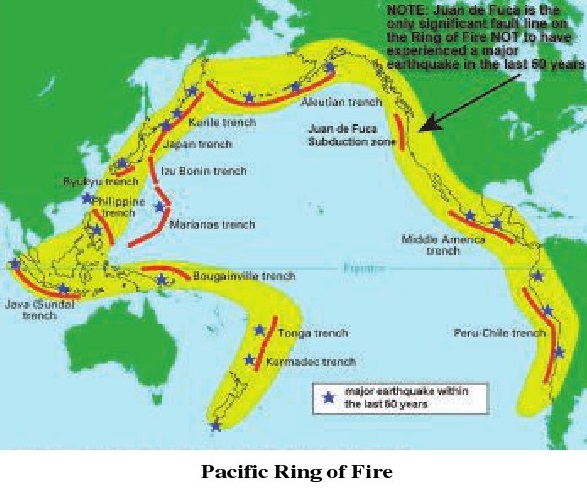
(1) Circum Pacific Belt :The most widespread and
intense earthquake activity occurs along subduction zones at convergent plate
boundaries. The Circum Pacific Belt extends in the west from Alaska to Kurile,
Japan, Mariana and the Philippine trenches, beyond which it is divided into two
branches, one going towards the Indonesian trench and other towards
Keramac-Tonga trench to the north-west of New Zealand. On the eastern side of
the Pacific, the earthquake zone follows the west South America.
The Mid-Atlantic Belt :This belt of earthquakes
extends along the mid oceanic ridges and several islands near the ridges of the
Atlantic ocean. The sea-floor spreading is the main cause of earthquakes in
this belt. Earthquakes of
moderate to mild intensity with shallow focus (less
than 70 km deep)are recorded in this belt. The Rift Valley of East Africa and
the Red Sea are considered as an extension to this belt.
The Mid-Continental Belt :This earthquake belt
extends along the Alpine
mountains system of Europe,North America, through
Asia Minor, Caucasia, Iran,Afghanistan and Pakistan to the
Himalayan mountain system,including Tibet, The
Pamir, Tien-Shan, Altai, and the mountains of China, Myanmar and Eastern
Siberia. This zone is characterised by larger earthquakes of shallow origin and
some of intermediate origin deep focus earthquakes are
almost absent in this belt.
Earthquakes in India :Most of the earthquakes in
India occur in Himalayan Belt. This is aregion of marked instability and is
characterised by several thrust planner. The north-western (including
Baluchistan and Hindukush and the Pamirs) and the north eastern corners at the
Himalayas are
particularly vulnerable as there are sharp changes
in strikes and rocks
are under great stress. The Indo-Gangetic alluvial
track is mostly
affected by earthquakes originating in the Himalayan
belt, but changes appear to be still taking place at the botton of the Gangetic
trough giving rise to the occasional earthquakes. The Sindh earthquake of 1819
and the Bihar earthquake of 1934 had their focii in this trough.

The Peninsular Indiais considered to be a
comparatively stable block while earthquakes of Koena (1967) and Latur (1993)
are examples of such activity in this region.


Consequences of Earthquakes:Throughout the histroy,
earthquakes have done great damage to both human lives and property. The major
consequence of the earthquakes are:
(1) Landslides : In the young fold mountains like
Andes, Rockies, Alps
and the Himalayas, the earthquakes result into
landslides which damage
the human settlements and disturb the transport
system. Financial & Commercial distruction is at its most 1n mountainous
regions because of
earthquakes.
(2) Loss of Human Lives : It has been estimated that
on an average about 15,000 people are killed every year by earthquakes. There
had been earthquakes of great magnitudes in the densely populated areas of the
world in which over one lakh people lost their lives, such as in Shenshi 1556
China massive earthquake killed 8,30,000 people.
(3) Fire Incidence : Contact of line electrical wire
and damage to blast
furnaces in factories and other fire related
appliances cause devastating
fires. Consequently, more damage to life and
property occurs from these fires. Control over such incidences also go beyond
possible.
(4) Loss of Human Property : Earthquakes pose a
significant threat to much of the world population. Earthquakes inflicts great
damage to buildings, roads, railways, dams, bridges, etc. The damage to
property is more serious in the areas of unconsolidated materials, such as
alluvium,colluvium, and artificially filled grounds and depressions. The
Gujarat earthquake in 2001 not only killed over 30,000 people, but also damaged
property of more than Rs. 2,000 crores. A much bigger destruction has
been caused by earthquake in Nepal in 2015.
(5) Flash Floods : Many a times, under the impact of
severe earthquakes, the dams and embankments develop fissures, which become the
cause of flash floods and big harm to human lives and property.
(6) Tsunami : The seismic waves, travelling through
the ocean and sea
water, result into high sea waves which are known as Tsunamis.

‘Tsunami’ is a Japanese term which was been universally adopted to
describe a large seismically generated sea waves which is capable of
considerable destruction in certain coastal areas,
especially where
submarine earthquakes occur. Although in the open
ocean the wave height may be less than 1 meter it steepens to heights of 15
meter or more on entering shallow coastal water. The wave length in the open
ocean is of the order of 100 to 150 km and rate of travel of a tsunami is
between 640 to 960 km/hr (400 - 600 miles/hr). Tsunamis can also be generated
by violent volcanic explosion at or below sea level. The Tsunami of 26th
December, 2004 as a consequence of the Aceh (Sumatra) earthquake,killed about
two lakh people in Indonesia, Thailand, Sn Lanka, Andaman & Nicobar
Islands, Tamilnadu (India), Maldives, Somalia, and Myanmar.The loss of property
and structure was enormous.
Regions with high risk of Tsunami, typically use
“Tsunami Warning System’ to warn the population before the wave reaches land.
Earthquake Forecasting :Making a forecast about the
occurences of an earthquake in a region, place and time is still difficult
proposition. One approach for making predictions ts to examine the history of
each plate boundary, and determine the frequency of earthquakes in the past.
Setsmologist then construct the maps that provide an estimate of expected
earthquake
activity.
The Chinese, on the basis of seismographic studies
on animal
behaviour, made fairly accurate predictions in the
seventies. Despite
animal behaviour and other phenomena, effective
earthquake predictions, which could save many lives and property damage is
providing to be an elusive goal.
EXERCISE
1. What do you mean by earthquake ?
2. Whatis ahypocenter ?
3. What is an epicentre ?
4. What is focus and epicentre ? Draw a diagram to
explain.
5. = Whichinstrument is used to measure earthquakes
?
6. What are the causes of earthquakes ?
7. What ts principle of Plate Techtonic ?
8. How humans are responsible for generating
earthquakes ?
9. What is Richter Scale ? How intensity of
earthquake is measured?
10. What is Pacific “Ring of Fire’ ?
11. Describe the distribution of earthquakes world
over.
12. Write in detail about earthquake zones in India.
13. Whatis Tsunami ?
14. Can we make predictions about eartquake? Write
note
Map work:
1. Show eartquake prone regions of the world on a
map.
2. Show earthquake zones of india on an outline map.


