CHAPTER NO.7 WINDS
CHAPTER NO.7 WINDS
Variation in air pressure at different places gives
birth to winds. Atmosphere
is a mixture of gases therefore it is highly mobile.
This mobility originates out of difference in air pressure of various places,
in simple words, known as winds. Winds move from high pressure to low pressure
regions. This cycle of winds moves on the whole Earth which divide and
distribute the temperature and humidity from Equator to Poles. Winds always try
to cover the disimilanties in pressure
of air.
According to Coriolis Effect which is known as
Ferrel’s law also, independently moving flows in Northern Hemisphere tend to
turn to their nght and in Southern Hemisphere towards their left because of
rotation of Earth. This effect is seen in winds also.
Winds are divided into three types on
the basis of term and tenure their of :—
1. Planetary or Perennial Winds
2. Seasonal Winds
3. Local Winds.
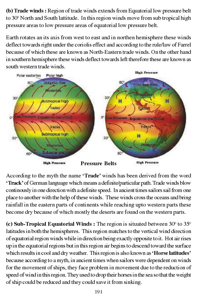
1. Planetary Winds : These winds move in one
direction throughout the year. They
move from high pressure areas of major pressure
belts to low pressure areas. These winds are also known as stable winds.
Eastern or Equatorial winds, Tradewinds,Western winds and Polarwinds are
examples of these winds.
(a) Eastren or Equatorial Winds : Region between 5°N
latitude to 5°S latitude is
known as Equatorial low pressure belt. This belt
receives vertical rays of sun because of which temperture is very high and
moreover the temperature of air present near the surface of Earth increases and
air starts moving upward. These are known as equatorial winds or Doldrums.
In this belt mostly the winds move vertically and
daily in the afternoon they bning heavy thunder showers, this region is also
known as Inter-tropical convergence zone (IICZ)because trade winds of both
hemispheres join here.

(b) Trade winds : Region of trade winds extends from
Equatorial low pressure belt to 30° North and South lattitude. In this region
winds move from sub tropical high pressure areas to low pressure areas of
equatorial low pressure belt.
Earth rotates an its axis from west to east and in
northen hemisphere these winds deflect towards right under the coriolis effect
and according to the rule/law of Farrel because of which these are known as
North-Eastern trade winds. On the other hand in southern hemisphere these winds
deflect towards left therefore these are known as
south western trade winds.

According to the myth the name ‘Trade’ winds has
been derived from the word
‘Track’ of German language which means a defi
nite/particular path. Trade winds blow continously in one direction with
adefimte speed. In ancient times sailors sail from one place to another with
the help of these winds. These winds cross the oceans and bring rainfall in the
eastern parts of continents while reaching upto western parts these
become dry because of which mostly the deserts are
found on the western parts.
(c) Sub-Tropical Equatorial Winds : The region is
situated between 30° to 35°
latitudes in both the hemispheres. This region
matches to the vertical wind direction of equatorial region winds while in
direction being exactly opposite toit. Hot air rises up in the equatonal regions
but in this region air begins to descend toward the surface
which results in cool and dry weather. This region
is also known as ‘Horse latitudes’because according to a myth, in ancient times
when sailors were dependent on winds for the movement of ships, they face
problem in movement due to the reduction of speed of wind in this region. They
used to drop their horses in the sea so that the weight
of ship could be reduced and they could save it from
sinking.
(d) Westerlies : Westerlies are the prevailing winds
in the middle latitudes (i.e.between 35 and 65 degree) in both hemispheres like
Trade winds, these winds also change their direction due to Coriollis Effect.
In northern hemisphere these blow from south west and in southern hemisphere
these blow from north west. These winds bring rainfall in the western parts of
continents.
Variations are found in speed and direction of these
winds due to the irregular division of water and land in northern hemisphere.
On the other hand most of southern hemisphere is covered by water in these
latitudes because of which these winds are more strong and regular in this
sphere. These winds also have some local names given by sailors like. Roaring
Forties for 40° latitude, "Furious Fifties" (50 to 60 degrees south)
and Shirking sixties for 60° latitude.
e) Polar winds : Polar winds blow from high pressure
polar regions to low pressure sub polar regions. Polar regions have low
temperature and these are covered by ice.These winds are dry and donot bring
rainfall because these are cold and do not attain moisture. Polar regions are
extremely cold and no one is living there because of which
we donot have much information about these regions.
But still we can say that as westerlies these winds are more regular in
southern hemisphere as compare to northern hemisphere.
Shifting of wind belts : Circulation of wind on the
earth’s relief 1s quite different from the above mentioned conditions. We all
know that earth rotates on its axis and it also
revolves around sun and moreover it is inclined at
23 1/2°. Because of this the position of sun on Earth change continously in a
year. Sun rays fall vertically on Equator as well as on Tropic of Cancer and
Tropic of Capricon.
Commonly we say that sun rays fall vertically on
equator but if we study world air pressure maps for the month of January and
July, we will come to know that air pressure belts change their position during
these months.
On June 21 sun rays fall vertically on Tropic of
Cancer. During these days Northern hemisphere has summer season and Southern
hemisphere has winter season.Equatorial high temperature and low pressure
regions shift towards north. Similarly other air pressure regions in northern
hemisphere shit toward north and regions in southern hemisphere shift towards
Equator.
Average situations are found twice in a year when
sun rays fall directly on the Equator i.e. March 21 and September 23. This
region has high temperature and low air pressure. Air pressure belts also shift
on December 22 but their direction is opposite to the direction of June 21.
Due to the change in the situation of Sun and Earth,
airpressure and wind belts shift from their definite position because of which
various effect have been observed in white world, some of which are as follows
:
i. Region which extends from 5° to 10° latitude on
the both sides of equator remians hot and humid due to low air pressure in
summer and in winters it remains dry by the effect of trade winds.
ii. The western parts of the continents which lie
between 30° to 45° lattitudes in both the hemispheres remain dry in summers due
to effect of north eastern and south eastern Trade winds. When air pressure
belts shift towards Equator in Northern hemisphere,Westerlies bring rainfall in
the western parts of the continents.
ii. Change in positioning of sun brings some
difference in weather and seasons
particularly in the regious falling between 60° and
70° latitudes in both the hemispheres.In Northen hemisphere where these higher
latitudes find effect of Westerlies, snow melts and vegetation starts growing.
Similarly, cold effect 1n winter brings dry weather with Polar winds.Generally
Western winds bring rain while Polar winds bring dry spell with them.
iv. Regions of monsoon winds have been created in
India and world due to the shifting of air pressure belts and wind belts.
Moreover due to this effect these winds blow completely opposite to each other
in summer and winter.

2.Seasonal or Temporary winds : Seasonal winds are
effected by the change in temperature and air pressure according to the change
in season Monsoon winds are the finest example of these winds.
Origin of Indian Monsoon
The Term ‘Monsoon’ has been derived from the Arabic
word ‘mausim’ — meaning
‘Season’. Monsoon is a wind system in which there is
compleat reversal of prevailing direction of winds after every six months, 1.e.
from Summer to Winter and Vice Versa.Concepts about the origin of Monsoon
Monsoon is acomplex meteorological phenomenon. Some of the important concepts
about the origin of monsoon have been discussed as under :
The Thermal Concept or Classical theory was
propounded of Halley in 1686.
According to this concept, Monsoons are the extended
land breeze and sea breeze on a large sale, produed by the differential heating
of continents and ocean bodies. During the summers in northern hemisphere, When
the sun rays are vertical over tropic of cancer, the huge landmas of Asia heats
quickly and develops a strong low pressure centre near lake Baikal (Siberia)
and Peshwara (Pakistan). Moreover the poleward
shift of the Inter tropical Convergence Zone (ITCZ)
to a position over Southern Asia reinforces the thermally induced low pressure
centre in comparison to this, the pressure over the oceans towards the Indian
and Pacific oceans is relatively high. Under these conditions, a sea to land
pressure gradient develops. Consequently, the surface air flow is from the high
pressure over the ocean towards the low pressure areas over the heated land.
Contrary to this during the winter season in the northern hemisphere these
develops a high pressure over near Baikal (Siberia) and Peshwar and Indian and
Pacific oceans are comparatively warm haivng a low pressure. The winds blow
from Land to Sea.
Dynamic Concept
The Dynamic Concept about the origin of Monsoon was
put forward by Flohn in 1951. In his opinion, The Monsoon is the result of
Seasonal Migration of Planetary Winds and pressure belts (fig.) The
Inter-Tropical Convergence Zone At the time of Summer Solstice (21 June), when
the sun rays are vertical over the tropic of cancer the North ITCZ is extended
upto 30°N latitude, covering South and South-East Asia and thus equitorial
westerlies are established over these Areas. The equatorial westerlies are
established over these areas (fig.) The equatorial westerlies become South-West
or Summer Monsoon. The NITCZ is associated with numerous atmospheric strams
(Cyclones).
Recent Concepts
Tibetan Plateau and the circum Polar whirl. In 1973.
The Monsoon Expedition
(Monex) was organized under the Joint Venture of the
former Soviet. Moon and India.On the basis of investigation the meteorologists
arrived at the conclusion that the Tibet Plateau plays a vital role in
initiating the monsoon circulation over the Indian Subcontinent. Tibet Plateau
1s a high table land with dimensions 2000 x (600— 1000)square Kilometer it has
an average height of 4 Kilometer. Tibet Plateau affects the atmosphere in two
ways (1) as a physical barrier, and (11) as a high level heat source.At the
begining of Juen the Sub tropical Jet Stream disappears completely over northrn
India. (fig.). At this time the Jet Stream shifts to
thenorth of Himalayas and Tibet and takes up a position at about 40°N. The
plateau of Tibet accentuates the northward displacement of Jet Stream. Thus the
abrupt onset of Summer Monsoon at the beginning of June is prompted by the
hydro-dynamic effect of the Himalayas and not by the thermally induced low
pressure centre over north West India in the middle of
October the Plateau Proves to be the most important
factor in causing the advance of the Jet Stream South of Himalayas or bifurcate
it into twoparts.
EL Nino and Monsoon
EL Nino meaning “Child Christ’ is a warm ocean
current appearing along the Peru (South America) coast generally in December.
It replaces the cold Peru or Humboldt current flowing along the Perm coast in
normal years. Under Normal conditions, the Peru is Cold Water Current, While
over the Western Pacific (Indonesia and Eatern Australia) the ocean current is
warm and deep. (Fig.). The appearance of EL-Nino ‘reversal’ the condition’
these develops warm conditions over the eastern Pacific (Peru Coast) and Cold
conditions in Western Pacific. Whenever this usually warm ocean current
(EL-Nino) is produced near the Peruvian C oast in South America, the amount of Precipitation
in the coastal regions is usually high while the Australian and Indonesian coasts
record drought conditions in brief, the occurrence of EL-Nino results into weak
Monsoon causing droughts floods and failure of crops.
The Indian ocean has been warming at a rate faster
than ever before (1.2°C during the Past Century). It is also the largest
consistent contributor to the global ocean warming treds. The Western Indian
Ocean, traditionally thought to have cooler sea surface temperatures than the
central and eastern Idnian Ocean, is surprisingly showing an even
stronger summer warming trend over the whole of the
20" Century then the central and eastern Indian Ocean.
EI-Ninois abnormal warming of sea surface of south
east Pacific ocean. during El-Nino event, Plankton does not flourish
luxuriantly. Krill fish disappears. Penguins in Antarctica climate observe baby
depression. Wild purple flower are found everywhere
on Atacama sands. Thermocline either go deeper or
changes its ends. Tropical diseses increases manyfold. Landslides intrupt the
system of life over predmont plains of Andes or the western coast of South
America.
South east Pacific ocean always remain a zone of
confrontation between counter equitonal current and Humboldt cold ocean
current, they tend to overpower each other. The constant upwelling of the cold
water of Humboldt current generates cold sea surface and high air pressure. If
west wind drift does not push sufficent cold water toit, counter
equitorial current establishs its warm water over
the larger areas. and raises sea surface temperature and induces El Nino
conditions.

A recent study focussed on the causes of its warming
and found that it was mainly due to EL-Nino events. Which are getting longer
and more frequent during recent decades,Possibly due to changing climate. These
EL Nino events eaken the summer westerly winds over the Indian Ocean. Winds
have the effect of cooling the sea surface. Strong winds cause evaporation and
loss of latent heat from the ocean leading to cooling.When the winds are
weakened the opposite happens - The ocean warms.
The study published recently in the ‘Journal of
Climate’ was undertaken by Dr. Roxy Mathew Koll of the Indian institute of
Tropical Meteorology, Pune and has found that the ocean atmospheric
Phenomenon-The EL-Nino, and the influence on the walker circulation were
responsible for periodic weakening of Monsoon Westerlies and led to abnormally
high summer sea surface temperature in Western Indian Ocean. The study has
found that “The Frequency and magnitude of El-Ninos have also increased
in the recent decades. Possibly due to global
warming. This means a piling up of heat on the Indian Ocean.
Mostly this effect has been observed in Asian
countries like India, Malayasia, China,Korea, Japan and Taiwan. Moreover, we
can also see this effect in USA, Northern Australia and Western Africa.
These winds originate due to the difference between
the temperature of land and water regions. Moreover, shifting of air pressure
belts due to change in the position of sunand
Earth also act as a major reason for the origin of
these winds.
Research about these winds is going on at world
level with advanced scientific
techniques so that we can understand the nature of
these winds accurately. Study about the higher atmospheric activities is also
going on, specially about the role of Jet stream.
La Nina:
The sea surfce temperature of south east pacific
ocean subsides by 3*to 5*Celsius. it leads to stronger Walker circulation.
Robust, south east trade winds carry more moisture and all the places will be
wetter than normal conditions on the eastern margins of the continents. Western
margins will exibit excessive drought conditions.
Pre advent of Monsoon, excessive rainfall over south
east and Eastern Africa are frequently associated with La-Nina. It occures when
counter equitorial current is weak and west wind drift pushes more water in
Humboldt current. protracted La Nina conditions takes place on occassions. Mid
1998 to early 2001, the sea surface temperature of south east Pacific ocean
remains excessively below normal. Last L
Nina occures in 2010-11. itis expected, 2017 is
having an extra ordinary La-Nina
year.
3. Local winds : Local winds originate due to the
difference between local relief and temperature and their effect is also local.
These winds are limited upto particular region and local people give name of
these winds. Name of these winds describe the affect on that particular region.
These winds can be further classified
into two parts :
(i) Hot winds
(11) Cold winds
(i) Hot Winds : Hot winds originate by advection of
hot air from warm source region and its movement toward adjacent region and
moreover temperature of wind rises when it descends in mountainous region.
Foehn : Fohn or Foehn is a type of dry, warm, down
slope wind that occurs in the
northern slopes of Alps mountain for its heal and
dryness is its dry adicbetic rate which increases temperature even upto 10°C
per kolometer while decending from mountain tops. In spring season these winds
increase the temperature because of which the ice melts and conducive
enviornment is created for the cultivation of wheat and growth of
fodder for animals. Increase is temperature and
decrease in humidity brings soothing effect in weather.
Chinook : These are the hot and dry winds which
descend toward Praire plains from Rocky mountains of North America,
particularly in Colorado, Wyoning, British Colmbia and Montana states in spring
season locally known as ‘Chinook’. ‘Chinook’ means ‘snow eater’ for locals.
Like Foehn winds these are also very helpful for local people. These winds
create conducive environment for the cultivation of crops, fodder
for animals and also give relief from cold. Canadian
Punjabis have given them a new name, “Shoonkan’ .

Santa Ana : These are hot and dry down slope winds
like Foehn and Chinook, they
blow in southern parts of California (USA) from
Santa Ana mountaineous regions to coastal plains. But these are harmful for
orchards and other vegetations in plains and trees start dying because of
dryness.
Loo : These are hot and dry winds which blow in
parts of northern Indiai.e. Punjab,Harayana, UP and Bihar during the month of
May and June. These are very harmful for human beings and every year large
number of people die because of these winds.
Khamsin : These are hot and dry winds which blow in
Egypt (Africa) from April to June and they carry dust particles with them. At
times the blow off big dewellings.
Sirocco : Hot, dry and dusty winds which blow
towards north from Sahara desert are knwon as ‘Sirocco’ winds. These winds
cross the Medditranian sea and enter in Italy and Spain. These winds attain
moisture while crossing the sea and bring rain laiden with dust. This rainfall
is harmful for crops.
Harmattan : Harmattan winds are hot and dry and they
blow from Sahara desert to
Gulf of Guinea and carry dust particles with them.
These winds decrease the humidity on the western coasts because of which local
people have given the name ‘doctors’to these winds.

(ii) Cold winds :
Mistral : Cold and dry winds blowing in spain and
France during winter season are known as Mistral winds. These winds blow from
Mediterranean plateaus to valleys of Rhone. These winds decrease the
temperature abruptly which affects the crops and human life.
Berg : Cold and dry winds decending from the
southern slopes of Alps mountain range are knwon as ‘Berg’. These winds affect
the eastern coasts of * Adriatic Sea’ (Italy).
Blizzard : Cold and dry snowy winds blowing in snow
/ice covered polar regions are known as Blizzard. As dust storms these winds
also decrease the visibility. These winds blow in USA, Canada, Siberia and
Antartica.
CYCLONES
Cyclone is a system of low pressure in which the
barometric graident is steep. Ina cyclone winds circulate, blowing inward in an
anti-clock-wise in the NorthernHemisphere and in aclockwise direction in the
Soutern Hemisphere.
The Cyclones are mainly of two types : (1) The
Temperate Cyclones also known as mid-latitude or extra tropical cyclone and
(11) the tropical cyclons known by different names in different countries of
the world, like Hurricane in U.S.A. and Typhoons in China.

(1) Temperature Cyclones (Mid latitude or Extra
tropic Cyclones or Depressions)
The low pressure system of Temperate latitude is
known as temperate cyclone,
recently replaced by the term ‘depressions’. In
general, a depress is a region where the atmospheric pressure is low relative
to that of its surroundings. The main characteristics of a temperate cyclone
are as under :
1. The isobars of a temperate cyclone are more or
less oval or elongated in shape.
2. The isobars of a lowest pressure is nearest to
the centre of depression.
3. In size (Diameter) it may be 150-3000 km
(100-2000 Miles).
4, It may be practically stationary or moving at
about800 to 1100 km (600 — 700
Miles) per day.
5. In the Northern Hemisphere, the winds of a
depressoin (Cyclone) circulate round the centre in an anticlockwise direction,
while in the Southern Hemisphere, the wind blow in aclockwise direction.

6. The temperate cyclone originates where warm
tropical air meets cold polar air, the former ascending over the latter with
the formation of frontal surfaces.
7. The depressions are characteristics with
unsettled and variable weather.
8. Their general direction of movement is from west
to eaast in themid-latitudes (westerlies) but specific paths are often curved
and sometime erratic.
9. The Average speed of the temperate cyclone is
about 30 to 50 km per hour or 800 to 1100 km per day. Speed is however, greater
in Winters than in the summers.
10. The rainfall is light to moderate which occurs
in the form of light showers. Fog and poor visibility are common in the
precipitation areas.
11.A few hours after the front has passed, clean
weather (Anticyclone) prevails.Before the arrival of a temperate cyclone the
high wispy cirrus clouds often in the form of mare’s tail appear first over the
Western Horizon As the front appraches, the clouds
lower and thicken Progressively to Cirrostratus,
altostratus and nimbostratus. The temperate cyclones rarely appear alone and
they move in form of a family. Most frequently, three or four such cyclone
forms a series, and this is called acyclone family.
Geographical Distribution of Temperate Cyclones :The
Major Areas and tracks of temperate cyclones have been shown in the map. In
General they occur between 0° to 60° latitudes in both the Hemispheres However,
in the Southern Hemisphere, the belt of maximum frequency of Cyclones is almost
cotinuous around the world. The Great strom in U.K.
1987 “Great Strom’ and Wilma in United States in 2005 were disastrous.
TROPICAL CYCLONES
Tropical Cyclones is a system of low pressure
occuring in tropical latitude extend from the Tropic of Cancer 2342°N to the
Tropic of Capricorn 232° south, encompassing the equitonal belt of Doldrums the
between 10°N and 10° South. They originate near the Western Flanks of the
oceans, where warm tropical currents supply an abundance of Water Vapours.
Tropical Cyclone is a powerful manifestation of earth’s energy and
moisture systems. The following weather conditions
are necessary for the origin of a tropical cyclone :
1. There should be continuous supply of abundant
warm and moist air.
2. The sea temperature in lower latitude should be
around 27°C.
3. They develops in a Inter Tropical Convergence
Zone (ITCZ).
4. Existence of weak tropical disturbance is also
required. The Pre-existing milk tropical disturbance, under favourable
conditions, intensifies and develops into a Violent tropical cyclones.
5. There should be anticyclonic circulation at the
height of 9 KM to 15 KM above the surface disturbance. The upper air
anticyclonic circulation sucks the air from the ocean surface above, thus the
upward movement of air is accelerated and low Pressure Centre at the surface is
intensified.

The central part of the Cyclone are known by
different names in different parts of the world. For example, in China Sea they
are called as Typhoons (From the Arabic Word *Toofan’. Baguios’ in Philippines,
*Taifu’ in Japan, in the Carribean Sea and the Gulf of Maxico as Hurricanes, in
the north West Australia as * Willy- Willies’ and in the Bay of Bengal, Arabian
Sea, Madagascar and Africa, as simply cyclones.
Approximately 80 tropical cyclones occur annually
worldwide. The Direction of winds in the tropical cyclones in anti clockwise in
the Northern Hemisphere and Clockwise in the Southern Hemisphere. The main
characteristics of tropical cyclones are as under :
1. In a tropical cyclone, the isobars are generally
circular, and close to each others resulting into steep Pressure gradient.
2. The Whole Cyclone has a diameter of about 150 to
300 Km.
3. They originate in the tropical regionon the
Western Margins of oceans, where the sea temperature exceed 27°C.
4. Most of them originates in the equitorial belt of
calms — the doldrums, when this belt is at its farthest limit from the equator.
5. They are most frequent in late summers and autumn
(August to October).
6. Violent Wind of Hurricane Speed (119 Km/h)
Circulate around the centre of ‘eye’of the strom — The eye of the Cyclone
covers a restricted area, being often about 15 to 30 per in diameter in the eye
of the Cyclone, the atmospheric pressure is excessively low, the air is
sometimes calm, and the sky clear. Passage of the eye may take about
half an hour, after which the strom strikes with
renewed ferocity, but with winds in the opposite direction.
7. A tropical cyclone is accompanied by towering
cumulonimbus clouds, torrential
rainfall, violent winds, thunder and lightning.
8. The Majority of Cyclones decay when they come
outer land or when they recurve northward over oceans.
The Tropical Cyclone cause immense domage to the
coastal areas as they destroy buildings, roads, railways, bridges and
shipyards. Moreover, trees are uprooted, crops damaed and Platations ruined.
Thousand of lives have been lost in Bangladesh, India,
Myanmar, Malaysia, Maxico, U.S.A. etc. because of
Such Cyclone in the year 2014
Cyclone ‘Hudhud’ ‘Nan, Nilofer and in 2015 *Ashobaa’
and Komen have caused
widespread damage in India (Map Given) In 2013
Mahasen Philin, Helen and Lehar
Cyclonic storm ‘Roanu' in the Bay of Bengal in may
2016 Andaman Islands and
remaining parts of North Andaman Sea were important.

TORNADOES
Tornado is a rapidly rotating column of air
developed around a very intense low
pressure centre. It is associated with dark funnel
shaped cloud and with extremely violent winds (More than 400 Km/hour). The
precise mechanism about the origin and development of a tornade is not fully
understood but the following atmospheric conditions appear to be necessary for
Tornado development:
(1) A layer of warm moist air at low latitude.
(2) A layer of dry air at higher altitude with an
intense cold front.
(3) Solar heating of the ground.
Tornados are generally regarded as having the
greatest wind intensity of all the meterological hazards. The updraught of
Tornado is associated with acold front squall line and cumulommbus clouds. The
tornado appears as a dark funnel cloud hanging from the base of a dense
cumulonimbus clouds. Tornadoes occurin many parts of the world but are most
strongly associated with and most common in the united states —about 1000 are
recorded there each year.
Devastation from a tornado is often complete with in
the narrow limit ofits path. The precise mechanism about the origin and
development of a tornados not fully understood but the following atmospheric
conditions appear to be necessary for Tornado development :

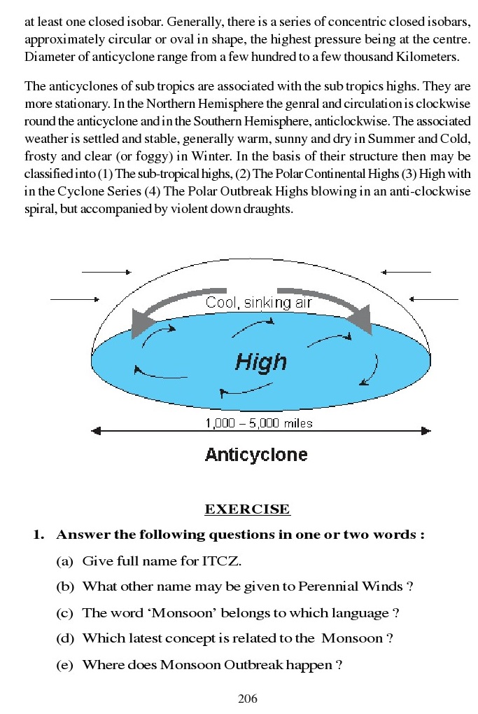
Anticyclone (The High)
The Concept of anticyclone was put forward by Sir francis
Galton in 1861. A centre of high pressure is known as anticyclone. In other
words, it is a region in which the atmospheric pressure is high compared with
that of adjacent areas, and which shows at least one closed isobar. Generally,
there is a series of concentric closed isobars,
approximately circular or oval in shape, the highest
pressure being at the centre.
Diameter of anticyclone range from a few hundred to
a few thousand Kilometers.
The anticyclones of sub tropics are associated with
the sub tropics highs. They are more stationary. In the Northern Hemisphere the
genral and circulation is clockwise
round the anticyclone and in the Southern
Hemisphere, anticlockwise. The associated weather is settled and stable,
generally warm, sunny and dry in Summer and Cold,frosty and clear (or foggy) in
Winter. In the basis of their structure then may be classified into (1) The
sub-tropical highs,
(2) The Polar Continental Highs
(3) High with in the Cyclone Series
(4) The Polar Outbreak Highs blowing in an
anti-clockwise spiral, but accompanied by violent down draughts.

EXERCISE
1. Answer the following questions in
one or two words :
(a) Give full name for ITCZ.
(b) What other name may be given to Perennial Winds
?
(c) The word ‘Monsoon’ belongs to which language ?
(d) Which latest concept is related to the Monsoon ?
(e) Where does Monsoon Outbreak happen ?
(f) What is local wind blowing in South-Western
Punjab in summer, known as ?
(g) What name is given to Cyclones in Australia ?
(h) What is Punjabi name for Tornado ?
(i) Who gave concept of anti-cyclone ?
G) What name is given to Fohen of Europe, in North
America ?
2. Answer the following questions in
one or two sentences :
(a) What do sailors name Western Winds at 40°, 50°
and 60°latitudes ?
(b) Name various perennial winds.
(c) What changes take place in Northern Hemisphere
under Farrel’s law ?
(d) Whatis Santa Anna?
(e) What is Blizzard ?
(f) What is difference between Hurricane and
Baiguious ?
(g) How Hud-hud, Nilofar and Nanook are related ?
3. Answer the following in 60 to 80
words :
(a) Describe Summer and Winter seasons in light of
anticyclones.
(b) What is EL-Nino, La Nina ? Explain.
(c) What is role of Tibet Plateau in process of
Monsoon ?
(d) Explain “Mango Showers’.
(e) Explain process of Shifting of pressure belts.
(f) What is Corriollis effect ? Howdoes it put
affect on Earth,explain.
(g) What do you understand by “Shookan’ ? Write
note.
4. Answer the following questions in
150 to 250 words :
(a) Classify Local Winds on the basis of tempeature.
(b) What are Perennial Winds ? Explain citinig its
types.
(c) Write notes on:
i) Corriollis Effect (ii) EL-Nino Effect
(d) Describe various principles related to origitn
of Monsoons.
(e) What are Cyclones ? Give short detail of
Tropical and Temprate Cyclones.
(f) Write notes on:
i) Tornado (ii) Anticyclone.